Gable Mount
Randonnée pédestre. En aller-retour. #Randonnée
- Distance: 1.9 mi
- Elevation gain: 755 ft
- Maximum elevation: 1,273 ft
- Elevation loss: 748 ft
- Minimum elevation: 518 ft
- Moving time: 47 m 50 s
- Moving speed: 2.3 mph
- Maximum speed: 5.3 mph
- Total time: 54 m 19 s
- Global speed: 2.0 mph
- Date: 07/04/2010
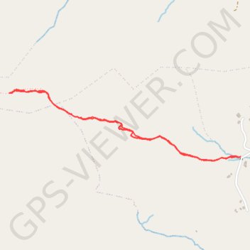
Interactive map
GPS track profile
About this GPS track
Name: Gable Mount GPS track, route, trail
Start: R345, Cloonbur ED, Conamara Municipal District, County Galway, Connacht, Irlande (53.52740 -9.39935)
End: R345, Cloonbur ED, Conamara Municipal District, County Galway, Connacht, Irlande (53.52738 -9.39956)
Coordinates: 53.52719 -9.41853 53.53070 -9.39935
Other GPS tracks
Click on a GPS track to view route, its statistics and profile.
Connemara - Day 4
#Bike
Distance: 44.8 mi • Elevation gain: 2,172 ft • Maximum elevation: 315 ft
Trace IRELAND
Distance: 936.2 mi • Elevation gain: 43,829 ft • Maximum elevation: 1,719 ft
RT5-1 Rosslare - Kinsale
Distance: 1,777.3 mi • Elevation gain: 89,833 ft • Maximum elevation: 1,378 ft
RT5-1 Rosslare - Kinsale
Distance: 2,402.9 mi • Elevation gain: 118,488 ft • Maximum elevation: 1,719 ft