Marche tonique ai
Interactive map
GPS track profile
About this GPS track
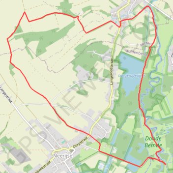
Name: Marche tonique ai GPS track, route, trail
Coordinates: 50.81489 4.61122 50.83757 4.64679
Other GPS tracks
Click on a GPS track to view route, its statistics and profile.
Rhin par la rive gauche
Suisse > Uri > Korporation Ursern > Andermatt
Vélo. En aller simple entre Andermatt et Hoek van Holland. Suisse centrale. #Vélo #SuisseCentrale #Alpes #Montagne #Nature
Distance: 903.8 mi • Elevation gain: 22,533 ft • Maximum elevation: 6,716 ft
French Divide
France > Hauts-de-France > Nord > Bray-Dunes
Traversez la France du nord au sud sur 2200 Km de sentiers, chemins et petites routes... Magique ! Vous connaissez la mythique Great Divide ? La French Divide est elle aussi en train de devenir une grande classique des traversées en bikepacking et sans assistance !
Distance: 1,376.9 mi • Elevation gain: 110,164 ft • Maximum elevation: 4,754 ft
Eurovelo 15 - Entire Route
Pays-Bas > Hollande-Méridionale > Hoek van Holland
Distance: 903.2 mi • Elevation gain: 27,156 ft • Maximum elevation: 6,716 ft
Tour d'Europe
France > Bretagne > Finistère > Concarneau > Landan Creis
Distance: 4,432.2 mi • Elevation gain: 146,335 ft • Maximum elevation: 7,982 ft
Hageland 21/4
Belgique > Bruxelles-Capitale > Bruxelles
Distance: 62.3 mi • Elevation gain: 2,536 ft • Maximum elevation: 381 ft
Atomium - Tervuren (No roadworks)
Belgique > Bruxelles-Capitale > Mutsaard
Distance: 49.6 mi • Elevation gain: 1,611 ft • Maximum elevation: 325 ft
Auderghem - Oudergem
Belgique > Bruxelles-Capitale > Auderghem
<p>From Avenue du Parc de Woluwe - Park van Woluwelaan 25;27, 1160 Auderghem - Oudergem, Belgium<br/> To Avenue du Parc de Woluwe - Park van Woluwelaan, 1160 Auderghem - Oudergem, Belgium</p> <p>Routing Recreational cycling - shortest</p>
Distance: 55.8 mi • Elevation gain: 1,827 ft • Maximum elevation: 387 ft
Rhin par la rive gauche
Suisse > Uri > Korporation Ursern > Andermatt
Distance: 903.6 mi • Elevation gain: 20,518 ft • Maximum elevation: 6,726 ft
TET_B-01-NW_20230301
Pays-Bas > Brabant-Septentrional > Reusel
Distance: 278.3 mi • Elevation gain: 10,413 ft • Maximum elevation: 538 ft
Eurovelo 15 - Strasbourg Rotterdam
France > Grand Est > Bas-Rhin > Strasbourg
comment ...
Distance: 554.1 mi • Elevation gain: 7,021 ft • Maximum elevation: 479 ft
Eurovéloroute-15-Route-du-Rhin
Suisse > Uri > Korporation Ursern > Andermatt
Distance: 931.4 mi • Elevation gain: 22,854 ft • Maximum elevation: 6,713 ft
80km Bello Gallico 2022 V1.1
Belgique > Brabant flamand > Louvain > Vieux-Héverlé
Distance: 50.1 mi • Elevation gain: 3,369 ft • Maximum elevation: 351 ft
Eurovelo 15 - Entire Route
Pays-Bas > Hollande-Méridionale > Hoek van Holland
Distance: 903.5 mi • Elevation gain: 25,433 ft • Maximum elevation: 6,726 ft
Rando Paris-Amsterdam
France > Île-de-France > Paris
Vélo. En aller simple entre Paris et Amsterdam. #Vélo
Distance: 442.2 mi • Elevation gain: 14,229 ft • Maximum elevation: 810 ft
Eurovelo 15 - Strasbourg Rotterdam
France > Grand Est > Bas-Rhin > Strasbourg
Distance: 554.1 mi • Elevation gain: 6,903 ft • Maximum elevation: 479 ft
Eurovelo 15 - Entire Route
Pays-Bas > Hollande-Méridionale > Hoek van Holland
Distance: 903.5 mi • Elevation gain: 25,433 ft • Maximum elevation: 6,726 ft
Auderghem - Oudergem
Belgique > Bruxelles-Capitale > Auderghem
<p>From Avenue Isidore Geyskens - Isidore Geyskenslaan 126, 1160 Auderghem - Oudergem, Belgium<br/> To Avenue Isidore Geyskens - Isidore Geyskenslaan 126, 1160 Auderghem - Oudergem, Belgium</p> <p>Routing Race cycling - shortest</p>
Distance: 53.4 mi • Elevation gain: 2,201 ft • Maximum elevation: 381 ft
Mons - Hannut-Blankenberge
Belgique > Liège > Liège > Flémalle > Mons-lez-Liège
Vélo. En aller simple entre Flémalle et Blankenberge. #Vélo
Distance: 137.7 mi • Elevation gain: 2,182 ft • Maximum elevation: 653 ft
Viré dans le Brabant Wallon avec J-L. ☀️🚴☕👍
Belgique > Bruxelles-Capitale > Bruxelles
Distance: 47.2 mi • Elevation gain: 3,058 ft • Maximum elevation: 440 ft
Hélécine
Belgique > Bruxelles-Capitale > Woluwe-Saint-Lambert
Distance: 63.9 mi • Elevation gain: 2,795 ft • Maximum elevation: 335 ft
De Guirsch à Gendron (définitif) J1
Belgique > Luxembourg > Arlon > Arlon > Guirsch
Distance: 628.8 mi • Elevation gain: 40,561 ft • Maximum elevation: 2,277 ft
BBB (A) (NE) 102km 675D+ Hageland
Belgique > Bruxelles-Capitale > Bruxelles
Distance: 63.2 mi • Elevation gain: 2,425 ft • Maximum elevation: 374 ft
Leuven
Belgique > Bruxelles-Capitale > Auderghem
<p>From Avenue Isidore Geyskens - Isidore Geyskenslaan 136, 1160 Auderghem - Oudergem, Belgium<br/> To Avenue Isidore Geyskens - Isidore Geyskenslaan 136, 1160 Auderghem - Oudergem, Belgium</p> <p>Routing Race cycling - shortest</p>
Distance: 42.8 mi • Elevation gain: 1,591 ft • Maximum elevation: 377 ft
Sven Nys loop BDC
Belgique > Bruxelles-Capitale > Bruxelles
Distance: 74.2 mi • Elevation gain: 2,963 ft • Maximum elevation: 354 ft
SV1 - Rotselaar - 93.2 km
Belgique > Bruxelles-Capitale > Woluwe-Saint-Lambert
Distance: 57.0 mi • Elevation gain: 1,650 ft • Maximum elevation: 338 ft
TET_B-01-NW_20230301
Pays-Bas > Brabant-Septentrional > Reusel
Distance: 278.3 mi • Elevation gain: 10,413 ft • Maximum elevation: 538 ft
De Guirsch à Gendron
Belgique > Luxembourg > Arlon > Arlon > Guirsch
Distance: 613.6 mi • Elevation gain: 41,873 ft • Maximum elevation: 2,277 ft
BBB (A) (N) 96km 300D+ Mechelen
Belgique > Bruxelles-Capitale > Bruxelles
Our rides take a break from climbing this week as we head north to the flatlands and canals around Mechelen. We'll pass under the Verbrande bridge which you might recognise from the posters advertising our Brusseleirs Spring Rando on 24th April. With a gentle breeze forecast from the North East, hopefully we won't have to contend…
Distance: 59.4 mi • Elevation gain: 1,447 ft • Maximum elevation: 377 ft
Lln
Belgique > Bruxelles-Capitale > Auderghem
<p>From Avenue Isidore Geyskens - Isidore Geyskenslaan 138, 1160 Auderghem - Oudergem, Belgium<br/> To Hoeilaartseweg 16, 1560 Hoeilaart, Belgium</p> <p>Routing Race cycling - shortest</p>
Distance: 39.2 mi • Elevation gain: 2,326 ft • Maximum elevation: 446 ft
National 46km Boucle Sud
Belgique > Brabant flamand > Louvain > Neerijse
Freddy Fredericks Planche de Nethen Galiberg Moskestraat Keistraat
Distance: 28.6 mi • Elevation gain: 1,752 ft • Maximum elevation: 312 ft