80km Bello Gallico 2022 V1.1
- Distance: 50.1 mi
- Elevation gain: 3,369 ft
- Maximum elevation: 351 ft
- Elevation loss: 3,369 ft
- Minimum elevation: 75 ft
Interactive map
GPS track profile
About this GPS track
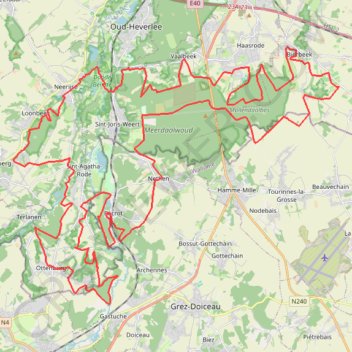
Name: 80km Bello Gallico 2022 V1.1 GPS track, route, trail
Start: Maurits Noëstraat, Vieux-Héverlé, Louvain, Brabant flamand, 3050, Belgique (50.82316 4.65868)
End: Maurits Noëstraat, Vieux-Héverlé, Louvain, Brabant flamand, 3050, Belgique (50.82314 4.65869)
Coordinates: 50.73900 4.59420 50.83031 4.77644
Other GPS tracks
Click on a GPS track to view route, its statistics and profile.
Rhin par la rive gauche
Suisse > Uri > Korporation Ursern > Andermatt
Vélo. En aller simple entre Andermatt et Hoek van Holland. Suisse centrale. #Vélo #SuisseCentrale #Alpes #Montagne #Nature
Distance: 903.8 mi • Elevation gain: 22,533 ft • Maximum elevation: 6,716 ft
Eurovelo 15 - Entire Route
Pays-Bas > Hollande-Méridionale > Hoek van Holland
Distance: 903.2 mi • Elevation gain: 27,156 ft • Maximum elevation: 6,716 ft
French Divide
France > Hauts-de-France > Nord > Bray-Dunes
Traversez la France du nord au sud sur 2200 Km de sentiers, chemins et petites routes... Magique ! Vous connaissez la mythique Great Divide ? La French Divide est elle aussi en train de devenir une grande classique des traversées en bikepacking et sans assistance !
Distance: 1,376.9 mi • Elevation gain: 110,164 ft • Maximum elevation: 4,754 ft
Atomium - Tervuren (No roadworks)
Belgique > Bruxelles-Capitale > Mutsaard
Distance: 49.6 mi • Elevation gain: 1,611 ft • Maximum elevation: 325 ft
Hageland 21/4
Belgique > Bruxelles-Capitale > Bruxelles
Distance: 62.3 mi • Elevation gain: 2,536 ft • Maximum elevation: 381 ft
GR5-001-3 GR 5 Belgie, Vlaanderen Zuid
Belgique > Anvers > Anvers > Zoersel
Distance: 114.8 mi • Elevation gain: 3,589 ft • Maximum elevation: 384 ft
Tour d'Europe
France > Bretagne > Finistère > Concarneau > Landan Creis
Distance: 4,432.2 mi • Elevation gain: 146,335 ft • Maximum elevation: 7,982 ft
Rhin par la rive gauche
Suisse > Uri > Korporation Ursern > Andermatt
Distance: 903.6 mi • Elevation gain: 20,518 ft • Maximum elevation: 6,726 ft
Auderghem - Oudergem
Belgique > Bruxelles-Capitale > Auderghem
<p>From Avenue du Parc de Woluwe - Park van Woluwelaan 25;27, 1160 Auderghem - Oudergem, Belgium<br/> To Avenue du Parc de Woluwe - Park van Woluwelaan, 1160 Auderghem - Oudergem, Belgium</p> <p>Routing Recreational cycling - shortest</p>
Distance: 55.8 mi • Elevation gain: 1,827 ft • Maximum elevation: 387 ft
TET_B-01-NW_20230301
Pays-Bas > Brabant-Septentrional > Reusel
Distance: 278.3 mi • Elevation gain: 10,413 ft • Maximum elevation: 538 ft
Eurovelo 15 - Strasbourg Rotterdam
France > Grand Est > Bas-Rhin > Strasbourg
comment ...
Distance: 554.1 mi • Elevation gain: 7,021 ft • Maximum elevation: 479 ft
Eurovéloroute-15-Route-du-Rhin
Suisse > Uri > Korporation Ursern > Andermatt
Distance: 931.4 mi • Elevation gain: 22,854 ft • Maximum elevation: 6,713 ft
A Travers Le Brabant 2022 - 110km
Belgique > Brabant wallon > Nivelles > Mont-Saint-Guibert
Route created on plotaroute.com
Distance: 69.1 mi • Elevation gain: 3,465 ft • Maximum elevation: 545 ft
GR128 De RiemSaint à Aachen (Belgique)
Belgique > Brabant flamand > Louvain > Louvain > Kessel-Lo > Bovenlo
Randonnée entre Leuven et Riemst. #Randonnée
Distance: 79.3 mi • Elevation gain: 3,110 ft • Maximum elevation: 413 ft
Eurovelo 15 - Entire Route
Pays-Bas > Hollande-Méridionale > Hoek van Holland
Distance: 903.5 mi • Elevation gain: 25,433 ft • Maximum elevation: 6,726 ft
Rando Paris-Amsterdam
France > Île-de-France > Paris
Vélo. En aller simple entre Paris et Amsterdam. #Vélo
Distance: 442.2 mi • Elevation gain: 14,229 ft • Maximum elevation: 810 ft
Morning Ride - Fietsrit - Strava by Stravatogpx app
Belgique > Brabant flamand > Hal-Vilvorde > Hoeilaert
Distance: 43.5 mi • Elevation gain: 3,730 ft • Maximum elevation: 486 ft
Gembloux
Belgique > Province de Namur > Namur > Gembloux
Distance: 58.2 mi • Elevation gain: 1,942 ft • Maximum elevation: 571 ft
Bercuit A
Belgique > Bruxelles-Capitale > Bruxelles
Distance: 54.6 mi • Elevation gain: 3,150 ft • Maximum elevation: 466 ft
BHCC 2022 #8 Bercuit-Chaumont Gistoux (Short) (E) 67km 700D+
Belgique > Bruxelles-Capitale > Bruxelles
With just 3 rounds to go, including the 'live' finale on Rue du Mystere, the action in the Brussels Hill Climb Challenge is hotting up. Last week we saw a fantastic 75 BBB members register a time up Bruyere du Wez, with congratulations to Dominique Rongvaux on becoming the new KOM on the climb after smashing the 8 year old record.…
Distance: 41.6 mi • Elevation gain: 2,671 ft • Maximum elevation: 433 ft
Bercuit B tourer
Belgique > Bruxelles-Capitale > Bruxelles
Distance: 37.7 mi • Elevation gain: 2,569 ft • Maximum elevation: 440 ft
🪨 BBB GRAVEL (8) (SE) 52km 680D+ E411 Tombeek (gravel variation)
Belgique > Bruxelles-Capitale > Bruxelles
(E411) Tombeek We've named this week's gravel route with a nod to the cobbled classic E3 Harelbeek, due to it also following the direction of a motorway, but the ride is very much in Brabantse Pijl country. With the outward and return routes often close to each other, there are also plenty of options to shorten the ride and add your…
Distance: 32.4 mi • Elevation gain: 2,149 ft • Maximum elevation: 440 ft
GR128 De Leuven (Belgique) à Maastricht (Pays-Bas)
Belgique > Brabant flamand > Louvain > Louvain > Héverlé
Randonnée entre Louvain et Maastricht. #Randonnée
Distance: 84.8 mi • Elevation gain: 3,304 ft • Maximum elevation: 410 ft
🪨 BBB GRAVEL (20.2) (E) 50km 600D+ Everberg
Belgique > Bruxelles-Capitale > Bruxelles
Route by James Watson, reviewed by Jérôme Grimonpon. This route towards Everberg is generally on good paths, although the short section near the motorway after Sterrebeek is technical at the best of times, and the path through Marnixbox before Jezus-Eik can also get muddy in places.
Distance: 31.3 mi • Elevation gain: 1,949 ft • Maximum elevation: 413 ft
Brabant W B 22/10
Belgique > Bruxelles-Capitale > Bruxelles
Distance: 48.1 mi • Elevation gain: 3,153 ft • Maximum elevation: 466 ft
Strada Bianchi - Huldenburg
Belgique > Bruxelles-Capitale > Bruxelles
Distance: 27.8 mi • Elevation gain: 1,722 ft • Maximum elevation: 427 ft
Eurovelo 15 - Strasbourg Rotterdam
France > Grand Est > Bas-Rhin > Strasbourg
Distance: 554.1 mi • Elevation gain: 6,903 ft • Maximum elevation: 479 ft
Eurovelo 15 - Entire Route
Pays-Bas > Hollande-Méridionale > Hoek van Holland
Distance: 903.5 mi • Elevation gain: 25,433 ft • Maximum elevation: 6,726 ft
Auderghem - Oudergem
Belgique > Bruxelles-Capitale > Auderghem
<p>From Avenue Isidore Geyskens - Isidore Geyskenslaan 126, 1160 Auderghem - Oudergem, Belgium<br/> To Avenue Isidore Geyskens - Isidore Geyskenslaan 126, 1160 Auderghem - Oudergem, Belgium</p> <p>Routing Race cycling - shortest</p>
Distance: 53.4 mi • Elevation gain: 2,201 ft • Maximum elevation: 381 ft
09: Brussels – Wavre (Developed with signs)
Belgique > Bruxelles-Capitale > Forest
Distance: 30.2 mi • Elevation gain: 1,627 ft • Maximum elevation: 443 ft
Mons - Hannut-Blankenberge
Belgique > Liège > Liège > Flémalle > Mons-lez-Liège
Vélo. En aller simple entre Flémalle et Blankenberge. #Vélo
Distance: 137.7 mi • Elevation gain: 2,182 ft • Maximum elevation: 653 ft
Viré dans le Brabant Wallon avec J-L. ☀️🚴☕👍
Belgique > Bruxelles-Capitale > Bruxelles
Distance: 47.2 mi • Elevation gain: 3,058 ft • Maximum elevation: 440 ft
01: Brussels – Wavre (Developed with signs)
Belgique > Brabant flamand > Hal-Vilvorde > Leeuw-Saint-Pierre
Developed with signs
Distance: 34.2 mi • Elevation gain: 1,545 ft • Maximum elevation: 443 ft
BBB (A) (SE) 99km 1.000D+ Perwez
Belgique > Bruxelles-Capitale > Bruxelles
Distance: 61.7 mi • Elevation gain: 3,406 ft • Maximum elevation: 538 ft
Rcc23_113_Km-16655342
Belgique > Brabant wallon > Nivelles > Wavre
Distance: 70.3 mi • Elevation gain: 4,380 ft • Maximum elevation: 528 ft
Hélécine
Belgique > Bruxelles-Capitale > Woluwe-Saint-Lambert
Distance: 63.9 mi • Elevation gain: 2,795 ft • Maximum elevation: 335 ft
De Guirsch à Gendron (définitif) J1
Belgique > Luxembourg > Arlon > Arlon > Guirsch
Distance: 628.8 mi • Elevation gain: 40,561 ft • Maximum elevation: 2,277 ft
BBB (A) (NE) 102km 675D+ Hageland
Belgique > Bruxelles-Capitale > Bruxelles
Distance: 63.2 mi • Elevation gain: 2,425 ft • Maximum elevation: 374 ft
Leuven
Belgique > Bruxelles-Capitale > Auderghem
<p>From Avenue Isidore Geyskens - Isidore Geyskenslaan 136, 1160 Auderghem - Oudergem, Belgium<br/> To Avenue Isidore Geyskens - Isidore Geyskenslaan 136, 1160 Auderghem - Oudergem, Belgium</p> <p>Routing Race cycling - shortest</p>
Distance: 42.8 mi • Elevation gain: 1,591 ft • Maximum elevation: 377 ft
Sven Nys loop BDC
Belgique > Bruxelles-Capitale > Bruxelles
Distance: 74.2 mi • Elevation gain: 2,963 ft • Maximum elevation: 354 ft
Perwez A
Belgique > Bruxelles-Capitale > Bruxelles
Distance: 62.6 mi • Elevation gain: 3,468 ft • Maximum elevation: 538 ft
SV1 - Rotselaar - 93.2 km
Belgique > Bruxelles-Capitale > Woluwe-Saint-Lambert
Distance: 57.0 mi • Elevation gain: 1,650 ft • Maximum elevation: 338 ft
TET_B-01-NW_20230301
Pays-Bas > Brabant-Septentrional > Reusel
Distance: 278.3 mi • Elevation gain: 10,413 ft • Maximum elevation: 538 ft
De Guirsch à Gendron
Belgique > Luxembourg > Arlon > Arlon > Guirsch
Distance: 613.6 mi • Elevation gain: 41,873 ft • Maximum elevation: 2,277 ft
BBB (A) (N) 96km 300D+ Mechelen
Belgique > Bruxelles-Capitale > Bruxelles
Our rides take a break from climbing this week as we head north to the flatlands and canals around Mechelen. We'll pass under the Verbrande bridge which you might recognise from the posters advertising our Brusseleirs Spring Rando on 24th April. With a gentle breeze forecast from the North East, hopefully we won't have to contend…
Distance: 59.4 mi • Elevation gain: 1,447 ft • Maximum elevation: 377 ft