SE16-Mora-Toledo
- Distance: 23.7 mi
- Elevation gain: 1,220 ft
- Maximum elevation: 2,431 ft
- Elevation loss: 1,850 ft
- Minimum elevation: 1,519 ft
Interactive map
GPS track profile
About this GPS track
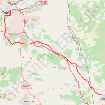
Name: SE16-Mora-Toledo GPS track, route, trail
End: Calle de la Hermandad, Tolède, Castille-La Manche, 45002, Espagne (39.85725 -4.02280)
Coordinates: 39.69158 -4.03410 39.86047 -3.78048
Other GPS tracks
Click on a GPS track to view route, its statistics and profile.
EuroVelo 1 (Spain)
Espagne > Andalousie > Côte occidentale > Ayamonte
Distance: 842.4 mi • Elevation gain: 47,858 ft • Maximum elevation: 4,331 ft
Southern section — European Divide Trail
France > Auvergne-Rhône-Alpes > Drôme > Valence
Distance: 1,506.1 mi • Elevation gain: 139,026 ft • Maximum elevation: 6,578 ft
Eurovelo 01 Spain + Portugal
France > Nouvelle-Aquitaine > Pyrénées-Atlantiques > Hendaye
Distance: 1,930.7 mi • Elevation gain: 100,367 ft • Maximum elevation: 4,931 ft
1 LUCENA - MONTPELLIER
Distance: 1,842.0 mi • Elevation gain: 96,785 ft • Maximum elevation: 3,438 ft
1 LUCENA - MONTPELLIER
Espagne > Andalousie > Lucena
Distance: 1,842.0 mi • Elevation gain: 96,785 ft • Maximum elevation: 3,438 ft
Stage 26: Valence to Saint-Jean-de-Fos — European Divide Trail
France > Auvergne-Rhône-Alpes > Drôme > Valence
Distance: 1,506.1 mi • Elevation gain: 139,026 ft • Maximum elevation: 6,578 ft
EuroVelo 1 (Spain)
Espagne > Andalousie > Côte occidentale > Ayamonte > Pozo del Camino > Fotea
Distance: 838.7 mi • Elevation gain: 44,754 ft • Maximum elevation: 4,331 ft
SE17-Toledo-Noves
Espagne > Castille-La Manche > Tolède
Total: 39.4km
Distance: 24.4 mi • Elevation gain: 1,119 ft • Maximum elevation: 1,903 ft