Callejón de Teno and Baracán Summit
- Distance: 6.2 mi
- Elevation gain: 1,913 ft
- Maximum elevation: 3,107 ft
- Elevation loss: 1,913 ft
- Minimum elevation: 1,736 ft
Interactive map
GPS track profile
About this GPS track
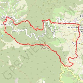
Name: Callejón de Teno and Baracán Summit GPS track, route, trail
Coordinates: 28.32722 -16.87801 28.34331 -16.84983
Other GPS tracks
Click on a GPS track to view route, its statistics and profile.
Ten_22_Buenavista - El Palmar - Masca
Espagne > Buenavista del Norte
Distance: 6.3 mi • Elevation gain: 2,946 ft • Maximum elevation: 2,966 ft
Rando Masca
Espagne > Buenavista del Norte > El Turrón
Randonnée entre Buenavista del Norte et El Palmar. #Randonnée
Distance: 3.8 mi • Elevation gain: 1,047 ft • Maximum elevation: 2,900 ft
Faro de Teno
Espagne > Buenavista del Norte > Teno Alto
Punta de Teno. #Randonnée
Distance: 4.2 mi • Elevation gain: 75 ft • Maximum elevation: 2,533 ft