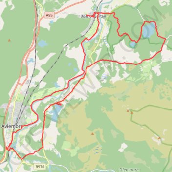
Aviemore to Loch Garten: A Tale of Trails and Trials
- Distance: 22.0 mi
- Elevation gain: 856 ft
- Maximum elevation: 801 ft
- Elevation loss: 856 ft
- Minimum elevation: 663 ft
- Moving time: 3 h 29 m
- Moving speed: 6.3 mph
- Maximum speed: 21.1 mph
- Total time: 4 h 27 m
- Global speed: 4.9 mph
- Date: 05/01/2024
Interactive map
GPS track profile
About this GPS track
Name: Aviemore to Loch Garten: A Tale of Trails and Trials GPS track, route, trail
Start: B9152, Aviemore, Highland, Scotland, PH22 1PX, United Kingdom (57.18327 -3.83335)
End: B9152, Aviemore, Highland, Scotland, PH22 1PX, United Kingdom (57.18319 -3.83326)
Coordinates: 57.17698 -3.83385 57.25063 -3.68692
Other GPS tracks
Click on a GPS track to view route, its statistics and profile.
Glenmore - Meall a' Bhuachaille - Ryvoan Bothy
United Kingdom > Scotland > Highland > Glenmore
Distance: 5.5 mi • Elevation gain: 1,850 ft • Maximum elevation: 2,648 ft