The Watcher in the Water
- Distance: 51.5 mi
- Elevation gain: 4,760 ft
- Maximum elevation: 984 ft
- Elevation loss: 4,780 ft
- Minimum elevation: 10 ft
Interactive map
GPS track profile
About this GPS track
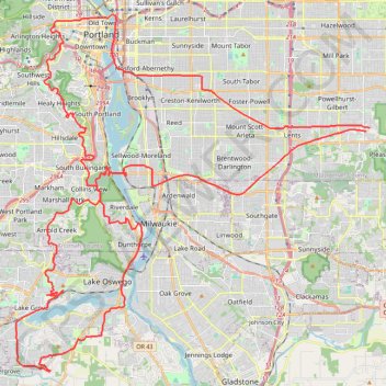
Name: The Watcher in the Water GPS track, route, trail
Coordinates: 45.38413 -122.72313 45.52806 -122.51993
Topography: Portland topographic map
Other GPS tracks
Click on a GPS track to view route, its statistics and profile.
Expedition to Sedum Ridge
United States > Oregon > Multnomah County
Distance: 133.4 mi • Elevation gain: 16,709 ft • Maximum elevation: 3,835 ft
Lake Oswego trails
United States > Oregon > Multnomah County > Portland
Happy Hour Lake Oswego
Distance: 43.2 mi • Elevation gain: 3,848 ft • Maximum elevation: 728 ft