Conwy Trail Running
Bryn
- Distance: 4.0 mi
- Elevation gain: 407 ft
- Maximum elevation: 341 ft
- Elevation loss: 394 ft
- Minimum elevation: 7 ft
- Moving time: 48 m 36 s
- Moving speed: 4.9 mph
- Maximum speed: 8.9 mph
- Total time: 55 m 42 s
- Global speed: 4.3 mph
- Date: 04/29/2024
Interactive map
GPS track profile
About this GPS track
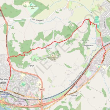
Name: Conwy Trail Running GPS track, route, trail
Start: Conway Road, Llandudno Junction, Conwy, Wales, LL31 9NH, United Kingdom (53.28431 -3.80887)
End: Bryn Marl Road, Mochdre, Conwy, Wales, LL28 5DT, United Kingdom (53.29212 -3.76236)
Coordinates: 53.28431 -3.80887 53.30473 -3.76002
Other GPS tracks
Click on a GPS track to view route, its statistics and profile.
TT22 J9 M7/06 : Heysham Port à Aberystwyth
Royaume-Uni > Angleterre > Lancashire > Lancaster > Morecambe
Distance: 215.9 mi • Elevation gain: 13,264 ft • Maximum elevation: 1,375 ft