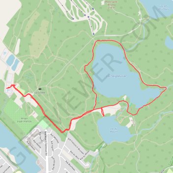
Boucle dans le Parc national du Mont-Saint-Bruno
Randonnée en boucle par le Chemin Saint-Gabriel, le Lac Seigneurial et le Lac du Moulin. #Randonnée #Boucle #Parc #Nature #Forêt #Lac
- Distance: 4.6 mi
- Elevation gain: 331 ft
- Maximum elevation: 371 ft
- Elevation loss: 338 ft
- Minimum elevation: 164 ft
- Moving time: 1 h 47 m
- Moving speed: 2.6 mph
- Maximum speed: 24.4 mph
- Total time: 2 h 21 m
- Global speed: 2.0 mph
- Date: 02/24/2024
Interactive map
GPS track profile
About this GPS track
Name: Boucle dans le Parc national du Mont-Saint-Bruno GPS track, route, trail
Coordinates: 45.54040 -73.34374 45.55165 -73.31600
Other GPS tracks
Click on a GPS track to view route, its statistics and profile.
Montréal - Lanoraie
Canada > Quebec > Urban agglomeration of Montreal > Montreal
Saint Lawrence River. #Bike #Montréal #Lanoraie #SaintLawrence
Distance: 43.6 mi • Elevation gain: 594 ft • Maximum elevation: 171 ft
Pierreville - Leclercville
Canada > Quebec > Urban agglomeration of Montreal > Montreal
#Bike #Pierreville #Leclercville #Atlantic
Distance: 75.1 mi • Elevation gain: 1,063 ft • Maximum elevation: 118 ft