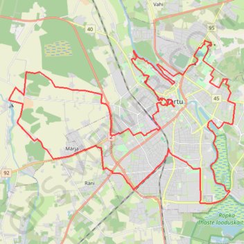
Kondimootor 50 KM (Tartu 2023)
Route created on plotaroute.com
- Distance: 31.1 mi
- Elevation gain: 732 ft
- Maximum elevation: 256 ft
- Elevation loss: 732 ft
- Minimum elevation: 95 ft
- Moving time: 10 h 2 m
- Moving speed: 3.1 mph
- Maximum speed: 3.3 mph
- Total time: 10 h 2 m
- Global speed: 3.1 mph
- Date: 11/14/2023
Interactive map
GPS track profile
About this GPS track
Name: Kondimootor 50 KM (Tartu 2023) GPS track, route, trail
End: 25, Laulupeo pst, Tähtvere, Tartu, Tartu linn, Tartu maakond, 51006, Estonia (58.38838 26.70311)
Coordinates: 58.34252 26.60661 58.40244 26.76491
Topography: Tartu topographic map
Other GPS tracks
Click on a GPS track to view route, its statistics and profile.
Stage 1: Arctic Ocean to Väylä — European Divide Trail
Distance: 1,730.5 mi • Elevation gain: 78,159 ft • Maximum elevation: 2,369 ft