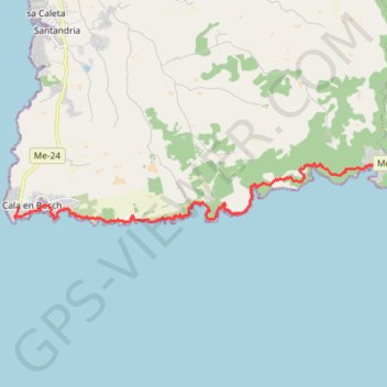
Cala en bosc à cala galdana
Randonnée entre Cap d'Artrutx et Ferreries. #Randonnée
- Distance: 11.0 mi
- Elevation gain: 745 ft
- Maximum elevation: 180 ft
- Elevation loss: 778 ft
- Minimum elevation: 0 ft
- Moving time: 4 h 41 s
- Moving speed: 2.7 mph
- Maximum speed: 3.8 mph
- Total time: 4 h 52 m
- Global speed: 2.3 mph
- Date: 07/18/2014
Interactive map
GPS track profile
About this GPS track
Name: Cala en bosc à cala galdana GPS track, route, trail
End: Camí de Cavalls, Cala Galdana, Ferreries, Minorque, Îles Baléares, Espagne (39.93881 3.95928)
Coordinates: 39.92226 3.82423 39.93886 3.95928
Other GPS tracks
Click on a GPS track to view route, its statistics and profile.
Southern section — European Divide Trail
France > Auvergne-Rhône-Alpes > Drôme > Valence
Distance: 1,506.1 mi • Elevation gain: 139,026 ft • Maximum elevation: 6,578 ft
1 LUCENA - MONTPELLIER
Distance: 1,842.0 mi • Elevation gain: 96,785 ft • Maximum elevation: 3,438 ft
1 LUCENA - MONTPELLIER
Espagne > Andalousie > Lucena
Distance: 1,842.0 mi • Elevation gain: 96,785 ft • Maximum elevation: 3,438 ft
TMCS 85 km
Espagne > Îles Baléares > Minorque > es Castell > Santa Anna
Distance: 52.6 mi • Elevation gain: 3,950 ft • Maximum elevation: 266 ft
Stage 26: Valence to Saint-Jean-de-Fos — European Divide Trail
France > Auvergne-Rhône-Alpes > Drôme > Valence
Distance: 1,506.1 mi • Elevation gain: 139,026 ft • Maximum elevation: 6,578 ft
PARCOURS-98km-IBP256-hiking
Espagne > Îles Baléares > Minorque > Port-Mahon > es Grau
Parcours créé avec gpstraces.net. Indice IBP de cette trace : 256
Distance: 60.4 mi • Elevation gain: 4,757 ft • Maximum elevation: 709 ft
Stage 26: Valence to Saint-Jean-de-Fos — European Divide Trail
France > Auvergne-Rhône-Alpes > Drôme > Valence
Distance: 1,012.7 mi • Elevation gain: 101,184 ft • Maximum elevation: 6,578 ft