Ménez Quelc'h - Cast
Interactive map
GPS track profile
About this GPS track
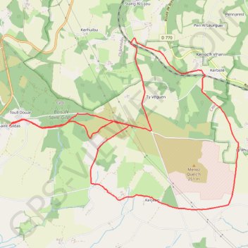
Name: Ménez Quelc'h - Cast GPS track, route, trail
Coordinates: 48.15391 -4.12354 48.17861 -4.07408
Other GPS tracks
Click on a GPS track to view route, its statistics and profile.
Nantes_a_brest
France > Pays de la Loire > Loire-Atlantique > Nort-sur-Erdre > La Blanchetière
Canal de Nantes à Brest
Distance: 216.3 mi • Elevation gain: 7,825 ft • Maximum elevation: 689 ft
Tro Breizh 2021
France > Bretagne > Côtes-d'Armor > Merdrignac > Les Rues d'à Bas
Tro breizh 2021
Distance: 792.8 mi • Elevation gain: 67,552 ft • Maximum elevation: 1,027 ft
Cast Menez hom 26km
France > Bretagne > Finistère > Cast > Ty Véguen
{DC1}Heure de fin : Durée totale : 0h00:00 Moyenne globale : - Pente moyenne : 0.00 % Aire incluse : 902.1980 ha Bornes emprise : 48.2247 -4.2660 ; 48.1663 -4.0983 Détails par segments distance | durée | vit.moy. | vit.max. | déniv. + | déniv - km | hh:mn:ss | km/h | km/h | m | m 25.71 | 00:00:00 | 0.0 | 0.0 | 0 | 0{DC2}
Distance: 16.0 mi • Elevation gain: 1,867 ft • Maximum elevation: 1,070 ft
Stations vertes de bretagne
France > Bretagne > Ille-et-Vilaine > Combourg > Le Vieux Châtel
Vélo. En aller simple entre La Chapelle-aux-Filtzméens et Combourg. #Vélo
Distance: 551.6 mi • Elevation gain: 27,402 ft • Maximum elevation: 1,086 ft
Sentier des douaniers
France > Normandie > Manche > Le Mont-Saint-Michel
Distance: 1,210.5 mi • Elevation gain: 92,792 ft • Maximum elevation: 397 ft
Gr34 t1
France > Normandie > Manche > Le Mont-Saint-Michel
Distance: 1,198.8 mi • Elevation gain: 88,606 ft • Maximum elevation: 417 ft
Sentier des douaniers
France > Pays de la Loire > Loire-Atlantique > Saint-Nazaire
Distance: 1,210.4 mi • Elevation gain: 92,608 ft • Maximum elevation: 397 ft
GR38 De Douarnenez à Châteauneuf-du-Faou (Finistère)
France > Bretagne > Finistère > Douarnenez > Ploaré > Sainte Croix
Randonnée sur le GR38 à travers le Finistère de Douarnenez à Châteauneuf-du-Faou via Kerguelen, Landudal, Kermadoret, Quimper, Saint Albin, Plogonnec et Locronan. #Randonnée
Distance: 60.4 mi • Elevation gain: 6,457 ft • Maximum elevation: 738 ft
Camp 2023 union de traces
France > Bretagne > Finistère > Lopérec
{DC1}Heure de fin : Durée totale : 0h00:00 Moyenne globale : - Pente moyenne : 0.00 % Aire incluse : 72953.2963 ha Bornes emprise : 48.3273 -4.2922 ; 48.1582 -3.7038 Détails par segments distance | durée | vit.moy. | vit.max. | déniv. + | déniv - km | hh:mn:ss | km/h | km/h | m | m 16.43 | 00:00:00 | 0.0 | 0.0 | 0 | 0 17.51 |…
Distance: 116.0 mi • Elevation gain: 11,421 ft • Maximum elevation: 955 ft
18km
France > Bretagne > Finistère > Châteaulin
Distance: 12.6 mi • Elevation gain: 1,470 ft • Maximum elevation: 702 ft
De Châteaulin à Rescourio
France > Bretagne > Finistère > Dinéault
Distance: 66.3 mi • Elevation gain: 4,275 ft • Maximum elevation: 830 ft
Aventureinterdite
France > Bretagne > Morbihan > Languidic > Pont-Augan
Distance: 197.7 mi • Elevation gain: 17,037 ft • Maximum elevation: 1,224 ft
Châteauneuf-du-Faou / Châteaulin
France > Bretagne > Finistère > Châteaulin
Distance: 26.4 mi • Elevation gain: 1,444 ft • Maximum elevation: 203 ft