Palisades Interstate Park Mountain Bike Ride
- Distance: 8.5 mi
- Elevation gain: 1,083 ft
- Maximum elevation: 531 ft
- Elevation loss: 1,079 ft
- Minimum elevation: 105 ft
- Moving time: 1 h 44 m
- Moving speed: 4.9 mph
- Maximum speed: 19.1 mph
- Total time: 1 h 48 m
- Global speed: 4.7 mph
- Date: 04/22/2024
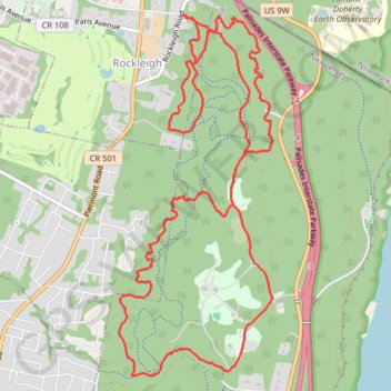
Interactive map
GPS track profile
About this GPS track
Name: Palisades Interstate Park Mountain Bike Ride GPS track, route, trail
Start: Rockleigh Road, Rockleigh, Bergen County, New Jersey, 07647, United States (41.00401 -73.92572)
End: Rockleigh Road, Rockleigh, Bergen County, New Jersey, 07647, United States (41.00406 -73.92561)
Coordinates: 40.97599 -73.93228 41.00406 -73.91654
Topography: Bergen County topographic map
Other GPS tracks
Click on a GPS track to view route, its statistics and profile.
Rockleigh Woods Sanctuary
United States > New Jersey > Bergen County > Rockleigh
Distance: 6.8 mi • Elevation gain: 1,066 ft • Maximum elevation: 492 ft
Alpine & Rockleigh
United States > New Jersey > Bergen County > Alpine
Palisades Interstate Park.
Distance: 9.3 mi • Elevation gain: 1,014 ft • Maximum elevation: 561 ft
Montréal - New York
Canada > Québec > Agglomération de Montréal > Montréal
Distance: 396.0 mi • Elevation gain: 13,563 ft • Maximum elevation: 988 ft