20-APR-06
- Distance: 45.8 mi
- Elevation gain: 8,917 ft
- Maximum elevation: 2,766 ft
- Elevation loss: 8,924 ft
- Minimum elevation: 3 ft
Interactive map
GPS track profile
About this GPS track
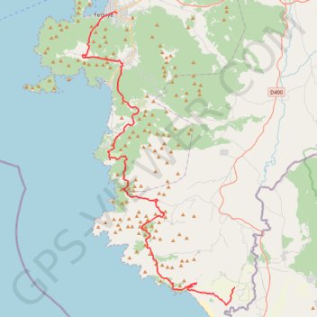
Name: 20-APR-06 GPS track, route, trail
End: Letoon, unknown, Kumluova, Seydikemer, Muğla, Région Égéenne, Turquie (36.33181 29.28865)
Coordinates: 36.31320 29.08735 36.62471 29.28865
Other GPS tracks
Click on a GPS track to view route, its statistics and profile.
Voie lycienne - Fethiye-Kalkan
Randonnée pédestre. En aller simple. #Randonnée
Distance: 47.8 mi • Elevation gain: 17,083 ft • Maximum elevation: 2,641 ft