Mecklenburg County Trail Run
- Distance: 4.4 mi
- Elevation gain: 331 ft
- Maximum elevation: 784 ft
- Elevation loss: 338 ft
- Minimum elevation: 663 ft
- Moving time: 1 h 10 m
- Moving speed: 3.7 mph
- Maximum speed: 7.4 mph
- Total time: 1 h 11 m
- Global speed: 3.7 mph
- Date: 04/29/2024
Interactive map
GPS track profile
About this GPS track
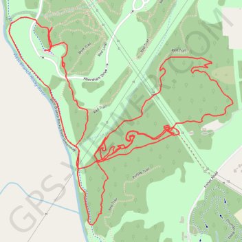
Name: Mecklenburg County Trail Run GPS track, route, trail
Start: Red Loop, Mecklenburg County, North Carolina, 28036, United States (35.49869 -80.80671)
End: Red Loop, Mecklenburg County, North Carolina, 28036, United States (35.49875 -80.80694)
Coordinates: 35.49118 -80.80884 35.50019 -80.79690
Topography: Mecklenburg County topographic map
Other GPS tracks
Click on a GPS track to view route, its statistics and profile.
Abersham Regional Park Trail Run
United States > North Carolina > Mecklenburg County
Distance: 4.5 mi • Elevation gain: 495 ft • Maximum elevation: 778 ft