Puig Gros
Randonnée en boucle depuis Valldemossa. #Randonnée #Boucle #Majorque #guillaumevk
- Distance: 6.4 mi
- Elevation gain: 1,906 ft
- Maximum elevation: 3,051 ft
- Elevation loss: 1,906 ft
- Minimum elevation: 1,398 ft
- Moving time: 3 h 23 m
- Moving speed: 1.9 mph
- Maximum speed: 3.6 mph
- Total time: 4 h 4 m
- Global speed: 1.6 mph
- Date: 09/24/2020
Interactive map
GPS track profile
About this GPS track
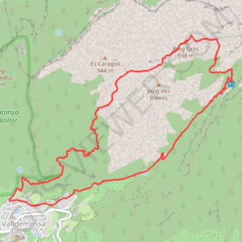
Name: Puig Gros GPS track, route, trail
Coordinates: 39.71286 2.62088 39.73237 2.65437
Other GPS tracks
Click on a GPS track to view route, its statistics and profile.
Southern section — European Divide Trail
France > Auvergne-Rhône-Alpes > Drôme > Valence
Distance: 1,506.1 mi • Elevation gain: 139,026 ft • Maximum elevation: 6,578 ft
Majorque - GR221
Espagne > Îles Baléares > Serra de Tramuntana > Andratx > Port d'Andratx
Distance: 66.9 mi • Elevation gain: 19,295 ft • Maximum elevation: 3,963 ft
GR221 tramuntana
Spain > Balearic Islands > Serra de Tramuntana > Pollença
Distance: 72.1 mi • Elevation gain: 19,196 ft • Maximum elevation: 3,967 ft
1 LUCENA - MONTPELLIER
Distance: 1,842.0 mi • Elevation gain: 96,785 ft • Maximum elevation: 3,438 ft
1 LUCENA - MONTPELLIER
Espagne > Andalousie > Lucena
Distance: 1,842.0 mi • Elevation gain: 96,785 ft • Maximum elevation: 3,438 ft
GR221 tramuntana
Spain > Balearic Islands > Serra de Tramuntana > Pollença
Distance: 72.1 mi • Elevation gain: 19,196 ft • Maximum elevation: 3,967 ft
GR221 tramuntana
Espagne > Îles Baléares > Serra de Tramuntana > Pollença
Distance: 72.1 mi • Elevation gain: 19,196 ft • Maximum elevation: 3,967 ft
Serra de Tramuntana ***
Espagne > Îles Baléares > Serra de Tramuntana > Pollença
Distance: 77.5 mi • Elevation gain: 14,406 ft • Maximum elevation: 3,976 ft
Stage 26: Valence to Saint-Jean-de-Fos — European Divide Trail
France > Auvergne-Rhône-Alpes > Drôme > Valence
Distance: 1,506.1 mi • Elevation gain: 139,026 ft • Maximum elevation: 6,578 ft
SES ILLES 2015 (ETAPA 5 - MALLORCA): PORT DE SÓLLER - PALMA ...
Espagne > Îles Baléares > Serra de Tramuntana > Sóller > Port de Sóller
Distance: 23.8 mi • Elevation gain: 2,999 ft • Maximum elevation: 1,414 ft
Majorque - Serra de Tramuntana
Espagne > Îles Baléares > Serra de Tramuntana > Andratx > Sant Elm
Distance: 72.1 mi • Elevation gain: 19,186 ft • Maximum elevation: 3,967 ft
Stage 26: Valence to Saint-Jean-de-Fos — European Divide Trail
France > Auvergne-Rhône-Alpes > Drôme > Valence
Distance: 1,012.7 mi • Elevation gain: 101,184 ft • Maximum elevation: 6,578 ft
OpenLayers.Feature.Vector_69674
Espagne > Îles Baléares > Serra de Tramuntana > Escorca > Lluc
Distance: 29.6 mi • Elevation gain: 9,085 ft • Maximum elevation: 3,967 ft
Monday Afternoon Flight
Espagne > Îles Baléares > Palma > Son Banya
Distance: 391.4 mi • Elevation gain: 87,385 ft • Maximum elevation: 8,478 ft