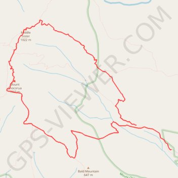
Mount Chocorua and Middle Sister Loop
Loop hike to Mount Chocorua and Middle Sister via Piper Trail, Weetamoo Trail, Hammond Trail, Liberty Trail, Jim Liberty Cabin, Middle Sister Trail, Carter Ledge Trail and Nickerson Ledge Trail in the White Mountain National Forest and the Mount Chocorua Scenic Area. #Hike #Loop #Mountain #Forest #Nature
- Distance: 8.2 mi
- Elevation gain: 2,703 ft
- Maximum elevation: 3,442 ft
- Elevation loss: 2,959 ft
- Minimum elevation: 784 ft
- Moving time: 4 h 27 m
- Moving speed: 1.8 mph
- Maximum speed: 3.5 mph
- Total time: 5 h 15 m
- Global speed: 1.6 mph
- Date: 10/03/2023
Interactive map
GPS track profile
About this GPS track
Name: Mount Chocorua and Middle Sister Loop GPS track, route, trail
Start: Piper Trail, Albany, Carroll County, New Hampshire, United States (43.94537 -71.23906)
End: Piper Trail, Albany, Carroll County, New Hampshire, United States (43.94042 -71.22923)
Coordinates: 43.93869 -71.27553 43.96663 -71.22923
Topography: Carroll County topographic map
Other GPS tracks
Click on a GPS track to view route, its statistics and profile.