Boucle rouge-15918860
- Distance: 6.2 mi
- Elevation gain: 997 ft
- Maximum elevation: 804 ft
- Elevation loss: 997 ft
- Minimum elevation: 49 ft
- Moving time: 3 h 19 m
- Moving speed: 1.9 mph
- Maximum speed: 1.9 mph
- Total time: 3 h 19 m
- Global speed: 1.9 mph
- Date: 12/08/2022
Interactive map
GPS track profile
About this GPS track
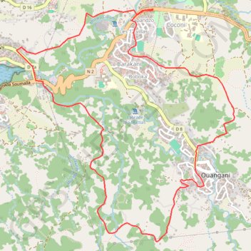
Name: Boucle rouge-15918860 GPS track, route, trail
Start: Route Nationale 2, Hapandzo, Coconi, Ouangani, Mayotte, 97670, France (-12.83376 45.13358)
End: Route Nationale 2, Hapandzo, Coconi, Ouangani, Mayotte, 97670, France (-12.83386 45.13355)
Coordinates: -12.85674 45.11969 -12.83376 45.14184
Other GPS tracks
Click on a GPS track to view route, its statistics and profile.
Boucle Noire-15928954
France > Mayotte > Tsingoni > Hachénoi
Distance: 32.0 mi • Elevation gain: 4,698 ft • Maximum elevation: 804 ft
Boucle Noire-15928954
France > Mayotte > Tsingoni > Hachénoi
Distance: 32.0 mi • Elevation gain: 4,698 ft • Maximum elevation: 804 ft
Boucle cascade Ouangani-16070964
France > Mayotte > Ouangani > Barakani
Distance: 3.0 mi • Elevation gain: 571 ft • Maximum elevation: 804 ft