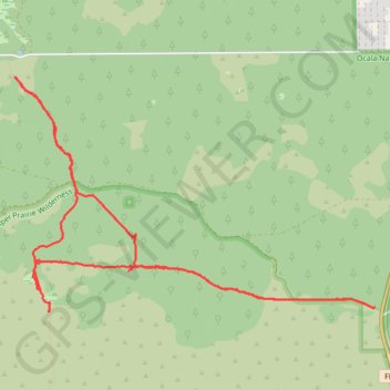
Yearling Trail
Loop hike via Yearling Trail, Long Cemetery and Florida Trail in the Juniper Prairie Wilderness and the Ocala National Forest. #Hike #Loop #Forest #Nature #Wilderness
- Distance: 8.6 mi
- Elevation gain: 240 ft
- Maximum elevation: 92 ft
- Elevation loss: 240 ft
- Minimum elevation: 23 ft
- Moving time: 4 h 15 m
- Moving speed: 2.0 mph
- Maximum speed: 24.1 mph
- Total time: 5 h 31 m
- Global speed: 1.6 mph
- Date: 04/20/2013
Interactive map
GPS track profile
About this GPS track
Name: Yearling Trail GPS track, route, trail
Start: FL 19, Yellow Bluff, Salt Springs, Marion County, Florida, United States (29.24515 -81.64860)
End: FL 19, Yellow Bluff, Salt Springs, Marion County, Florida, United States (29.24517 -81.64862)
Coordinates: 29.24467 -81.68844 29.26738 -81.64860
Topography: Marion County topographic map