Zeopoxa Running
- Distance: 8.6 mi
- Elevation gain: 190 ft
- Maximum elevation: 26 ft
- Elevation loss: 180 ft
- Minimum elevation: 10 ft
- Moving time: 1 h 45 m
- Moving speed: 4.9 mph
- Maximum speed: 7.0 mph
- Total time: 1 h 45 m
- Global speed: 4.9 mph
- Date: 07/11/2023
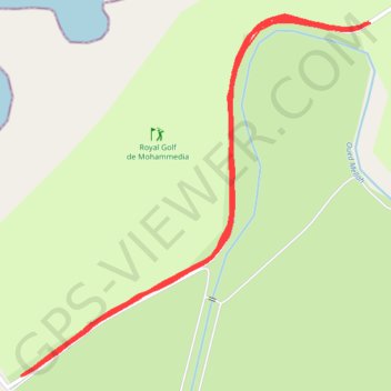
Interactive map
GPS track profile
About this GPS track
Name: Zeopoxa Running GPS track, route, trail
Coordinates: 33.69516 -7.41447 33.70345 -7.40483
Other GPS tracks
Click on a GPS track to view route, its statistics and profile.
Maroc en boucle depuis Tanger
Maroc > pachalik de Tanger > Tanger
Distance: 1,882.0 mi • Elevation gain: 89,413 ft • Maximum elevation: 7,549 ft
Marruecos Junio 2019. De Berguent a Esmara
Maroc > Pachalik de Ain Bni Mathar > Ain Bni Mathar
Distance: 1,411.5 mi • Elevation gain: 38,770 ft • Maximum elevation: 4,770 ft