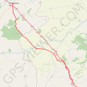
SE28-MotaDM-Villalpando
Total: 38.1km
- Distance: 23.6 mi
- Elevation gain: 702 ft
- Maximum elevation: 2,730 ft
- Elevation loss: 876 ft
- Minimum elevation: 2,264 ft
Interactive map
GPS track profile
About this GPS track
Name: SE28-MotaDM-Villalpando GPS track, route, trail
Start: Calle San Juan, Mota del Marqués, Valladolid, Castille-et-León, 47120, Espagne (41.63288 -5.17747)
End: Plaza Angustias, Villalpando, Zamora, Castille-et-León, Espagne (41.86413 -5.41349)
Coordinates: 41.63288 -5.41566 41.86413 -5.17747
Other GPS tracks
Click on a GPS track to view route, its statistics and profile.
Southern section — European Divide Trail
France > Auvergne-Rhône-Alpes > Drôme > Valence
Distance: 1,506.1 mi • Elevation gain: 139,026 ft • Maximum elevation: 6,578 ft
EuroVelo 1 (Spain)
Espagne > Andalousie > Côte occidentale > Ayamonte
Distance: 842.4 mi • Elevation gain: 47,858 ft • Maximum elevation: 4,331 ft
Eurovelo 01 Spain + Portugal
France > Nouvelle-Aquitaine > Pyrénées-Atlantiques > Hendaye
Distance: 1,930.7 mi • Elevation gain: 100,367 ft • Maximum elevation: 4,931 ft
Stage 26: Valence to Saint-Jean-de-Fos — European Divide Trail
France > Auvergne-Rhône-Alpes > Drôme > Valence
Distance: 1,506.1 mi • Elevation gain: 139,026 ft • Maximum elevation: 6,578 ft
EuroVelo 1 (Spain)
Espagne > Andalousie > Côte occidentale > Ayamonte > Pozo del Camino > Fotea
Distance: 838.7 mi • Elevation gain: 44,754 ft • Maximum elevation: 4,331 ft
De Villeneuve-sur-Lot à Guimarães
France > Nouvelle-Aquitaine > Lot-et-Garonne > Villeneuve-sur-Lot
Distance: 1,257.8 mi • Elevation gain: 72,575 ft • Maximum elevation: 4,393 ft
Etape 6 Briviesca - Alaejos
Espagne > Castille-et-León > Briviesca
Distance: 153.7 mi • Elevation gain: 7,182 ft • Maximum elevation: 3,202 ft