Monte Gozzi - Corse Sud
Randonnée pédestre. Depuis Appietto. #Randonnée
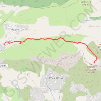
- Distance: 4.0 mi
- Elevation gain: 1,125 ft
- Maximum elevation: 2,300 ft
- Elevation loss: 1,319 ft
- Minimum elevation: 1,214 ft
- Moving time: 2 h 36 m
- Moving speed: 1.5 mph
- Maximum speed: 26.3 mph
- Total time: 4 h 13 m
- Global speed: 0.9 mph
- Date: 11/14/2014
Interactive map
GPS track profile
About this GPS track
Name: Monte Gozzi - Corse Sud GPS track, route, trail
Coordinates: 42.00519 8.76322 42.01184 8.79630
Other GPS tracks
Click on a GPS track to view route, its statistics and profile.
1 LUCENA - MONTPELLIER
Distance: 1,842.0 mi • Elevation gain: 96,785 ft • Maximum elevation: 3,438 ft
J1 de Bastia à Ajaccio
France > Corse > Haute-Corse > Bigorno
Dim 3 10 21
Distance: 102.5 mi • Elevation gain: 10,108 ft • Maximum elevation: 3,839 ft
1 LUCENA - MONTPELLIER
Espagne > Andalousie > Lucena
Distance: 1,842.0 mi • Elevation gain: 96,785 ft • Maximum elevation: 3,438 ft
Ajaccio - Bastia par le sud
France > Corse > Corse-du-Sud > Ajaccio
Vélo. En aller simple entre Ajaccio et Bastia. #Vélo
Distance: 209.6 mi • Elevation gain: 15,574 ft • Maximum elevation: 1,824 ft
TG6ak
France > Corse > Haute-Corse > Bastia
tour de corse vélo de voyage trace en préparation
Distance: 503.9 mi • Elevation gain: 73,199 ft • Maximum elevation: 4,849 ft