Indian Path Trail
#Hiking #Wilderness #Backcountry
- Distance: 3.3 mi
- Elevation gain: 295 ft
- Maximum elevation: 210 ft
- Elevation loss: 295 ft
- Minimum elevation: 26 ft
- Moving time: 1 h 29 m
- Moving speed: 2.2 mph
- Maximum speed: 4.5 mph
- Total time: 2 h 6 m
- Global speed: 1.6 mph
- Date: 05/04/2024
Interactive map
GPS track profile
About this GPS track
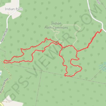
Name: Indian Path Trail GPS track, route, trail
Coordinates: 44.30660 -64.34323 44.31275 -64.32519