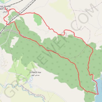
T2020-06-28-16-24
- Distance: 17.8 mi
- Elevation gain: 1,975 ft
- Maximum elevation: 850 ft
- Elevation loss: 1,982 ft
- Minimum elevation: 20 ft
- Moving time: 7 h 20 m
- Moving speed: 2.4 mph
- Maximum speed: 5.7 mph
- Total time: 8 h 21 m
- Global speed: 2.1 mph
- Date: 06/28/2020
Interactive map
GPS track profile
About this GPS track
Name: T2020-06-28-16-24 GPS track, route, trail
Coordinates: 35.54588 -5.91966 35.61134 -5.83196
Other GPS tracks
Click on a GPS track to view route, its statistics and profile.
Maroc en boucle depuis Tanger
Maroc > pachalik de Tanger > Tanger
Distance: 1,882.0 mi • Elevation gain: 89,413 ft • Maximum elevation: 7,549 ft
Saved_2020-06-29-15-54
Maroc > cercle d'Assilah > Hjar Ennhal > Hjar Ennhal
Distance: 17.7 mi • Elevation gain: 1,975 ft • Maximum elevation: 850 ft