26 juil. 2022 , c , pompei aller
comment ...
- Distance: 2.1 mi
- Elevation gain: 115 ft
- Maximum elevation: 115 ft
- Elevation loss: 102 ft
- Minimum elevation: 52 ft
- Moving time: 1 h 11 m
- Moving speed: 1.7 mph
- Maximum speed: 8.0 mph
- Total time: 2 h 58 m
- Global speed: 0.7 mph
- Date: 07/26/2022
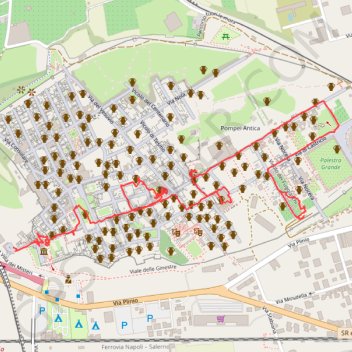
Interactive map
GPS track profile
About this GPS track
Name: 26 juil. 2022 , c , pompei aller GPS track, route, trail
Start: Masseria Curato, Pompei, Napoli, Campanie, 80045, Italie (40.74840 14.48220)
Coordinates: 40.74830 14.48220 40.75248 14.49419
Other GPS tracks
Click on a GPS track to view route, its statistics and profile.
Percorso selezionato
Italie > Lombardie > Côme > Côme
Percorso calcolato con http://www.bicitalia.org/it/routing-gpx
Distance: 959.4 mi • Elevation gain: 58,894 ft • Maximum elevation: 3,392 ft