Maratona de Lisboa - 42.2km
- Distance: 26.0 mi
- Elevation gain: 1,191 ft
- Maximum elevation: 128 ft
- Elevation loss: 1,211 ft
- Minimum elevation: -13 ft
Interactive map
GPS track profile
About this GPS track
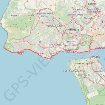
Name: Maratona de Lisboa - 42.2km GPS track, route, trail
End: Praça do Comércio, São Nicolau, Santa Maria Maior, Lisbonne, 1100-148, Portugal (38.70786 -9.13660)
Coordinates: 38.67706 -9.48494 38.71184 -9.13660
Other GPS tracks
Click on a GPS track to view route, its statistics and profile.
Camino Portuguese - Coastal/Monacal
Portugal > Lisbonne > Lisbonne
<p> A route covering the Camino Portuguese - The Portuguese Way, starting from Lisbon to Porto and from there the coastal route.</p> <p> This is a version of the Camino Portuguese names Route Monacal, as it goes along the coast from Porto and does not follow the more common central route.</p> <p> It covers the camino Portuguese from…
Distance: 394.3 mi • Elevation gain: 18,038 ft • Maximum elevation: 1,493 ft
Eurovelo 01 Spain + Portugal
France > Nouvelle-Aquitaine > Pyrénées-Atlantiques > Hendaye
Distance: 1,930.7 mi • Elevation gain: 100,367 ft • Maximum elevation: 4,931 ft
10 mars 2022 08:44:47
Portugal > Lisbonne > Lisbonne
Distance: 13.3 mi • Elevation gain: 1,788 ft • Maximum elevation: 308 ft
01: Lisboa – Azenhas do Mar (Developed)
Portugal > Lisbonne > Lisbonne
Developed
Distance: 34.3 mi • Elevation gain: 1,942 ft • Maximum elevation: 833 ft