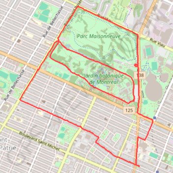
Parc Maisonneuve et jardin botanique de Montréal
Randonnée / course à pied en boucle par le parc Maisonneuve et jardin botanique de Montréal. #Randonnée #Course #Boucle #Parc #Nature #Forêt #Ville
- Distance: 6.6 mi
- Elevation gain: 203 ft
- Maximum elevation: 223 ft
- Elevation loss: 207 ft
- Minimum elevation: 105 ft
- Moving time: 1 h 3 m
- Moving speed: 6.3 mph
- Maximum speed: 8.3 mph
- Total time: 1 h 4 m
- Global speed: 6.1 mph
- Date: 02/11/2024
Interactive map
GPS track profile
About this GPS track
Name: Parc Maisonneuve et jardin botanique de Montréal GPS track, route, trail
Coordinates: 45.54768 -73.57731 45.56912 -73.55181
Other GPS tracks
Click on a GPS track to view route, its statistics and profile.
Base
Canada > Québec > Agglomération de Montréal > Montréal
Objectif 139 bpm pendant 46 minutes.
Distance: 6.5 mi • Elevation gain: 141 ft • Maximum elevation: 197 ft
Montréal - Lanoraie
Canada > Quebec > Urban agglomeration of Montreal > Montreal
Saint Lawrence River. #Bike #Montréal #Lanoraie #SaintLawrence
Distance: 43.6 mi • Elevation gain: 594 ft • Maximum elevation: 171 ft
Salaberry-de-Valleyfield - Montréal
Canada > Quebec > Beauharnois-Salaberry > Salaberry-de-Valleyfield
#Bike
Distance: 55.9 mi • Elevation gain: 1,191 ft • Maximum elevation: 230 ft
East Hawkesbury - Montréal
Canada > Ontario > Prescott and Russell Counties > East Hawkesbury
#Bike #EastHawkesbury #Montréal
Distance: 56.8 mi • Elevation gain: 1,289 ft • Maximum elevation: 299 ft
Pierreville - Leclercville
Canada > Quebec > Urban agglomeration of Montreal > Montreal
#Bike #Pierreville #Leclercville #Atlantic
Distance: 75.1 mi • Elevation gain: 1,063 ft • Maximum elevation: 118 ft