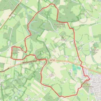
Tankenberg 2015
- Distance: 5.9 mi
- Elevation gain: 344 ft
- Maximum elevation: 279 ft
- Elevation loss: 341 ft
- Minimum elevation: 154 ft
Interactive map
GPS track profile
About this GPS track
Name: Tankenberg 2015 GPS track, route, trail
Start: Plechelmusstraat, de Lutte, Losser, Overijssel, Netherlands, 7587 AM, Netherlands (52.31505 6.98714)
End: Plechelmusstraat, de Lutte, Losser, Overijssel, Netherlands, 7587 AM, Netherlands (52.31507 6.98723)
Coordinates: 52.31035 6.95299 52.33507 6.98723
Other GPS tracks
Click on a GPS track to view route, its statistics and profile.
Stage 14: Frederikshavn to Aars — European Divide Trail
Danemark > Jutland du Nord > Frederikshavn
Distance: 1,382.7 mi • Elevation gain: 94,114 ft • Maximum elevation: 4,557 ft
Jour 18 / 27 Juin 2022
Distance: 405.5 mi • Elevation gain: 6,020 ft • Maximum elevation: 381 ft