Wilsons Promontory Southern Circuit
Interactive map
GPS track profile
About this GPS track
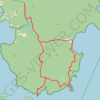
Name: Wilsons Promontory Southern Circuit GPS track, route, trail
Coordinates: -39.13643 146.35582 -39.03254 146.43068
Other GPS tracks
Click on a GPS track to view route, its statistics and profile.
Wilsons Promontory Circuit
Australia > Victoria > Tidal River
Wilsons Promontory Marine National Park. #Hike #Loop #WilsonsPromontory
Distance: 45.1 mi • Elevation gain: 10,627 ft • Maximum elevation: 1,768 ft
2023 Prom 100 km Run
Australia > Victoria > Tidal River
Distance: 63.0 mi • Elevation gain: 12,956 ft • Maximum elevation: 1,007 ft
Wilsons Promontory Southern Circuit
Distance: 28.7 mi • Elevation gain: 5,633 ft • Maximum elevation: 1,007 ft
Wilsons Promontory Southern Circuit
Distance: 28.7 mi • Elevation gain: 5,656 ft • Maximum elevation: 1,007 ft