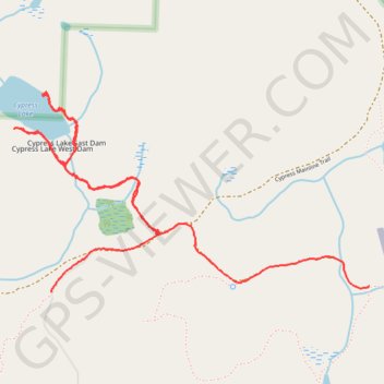
Cypress Lake (Cypress Island)
Hike to Cypress Lake via Cypress Island Trail in the Cypress Highlands Natural Area Preserve. #Hike #Lake #Island #Nature #Forest
- Distance: 3.0 mi
- Elevation gain: 522 ft
- Maximum elevation: 1,109 ft
- Elevation loss: 518 ft
- Minimum elevation: 823 ft
- Moving time: 1 h 8 m
- Moving speed: 2.7 mph
- Maximum speed: 5.3 mph
- Total time: 1 h 23 m
- Global speed: 2.2 mph
- Date: 02/16/2024
Interactive map
GPS track profile
About this GPS track
Name: Cypress Lake (Cypress Island) GPS track, route, trail
Start: Cypress Mainline Trail, Skagit County, Washington, United States (48.57234 -122.71096)
End: Old Airfield Trail, Skagit County, Washington, United States (48.57257 -122.69219)
Coordinates: 48.57234 -122.71314 48.58015 -122.69219
Topography: Skagit County topographic map