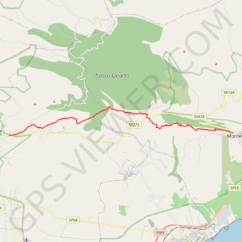
De Monte Sant'Angelo à San Giovanni Rotondo
Randonnée entre Monte Sant'Angelo et San Giovanni Rotondo. #Randonnée
- Distance: 12.8 mi
- Elevation gain: 1,076 ft
- Maximum elevation: 2,828 ft
- Elevation loss: 1,860 ft
- Minimum elevation: 1,516 ft
Interactive map
GPS track profile
About this GPS track
Name: De Monte Sant'Angelo à San Giovanni Rotondo GPS track, route, trail
Start: Via Castello, Junno, Monte Sant'Angelo, Foggia, Pouilles, 71037, Italie (41.70749 15.95380)
End: SS272, San Giovanni Rotondo, Foggia, Pouilles, 71013, Italie (41.70556 15.74909)
Coordinates: 41.70556 15.74909 41.72523 15.95380
Other GPS tracks
Click on a GPS track to view route, its statistics and profile.
Percorso selezionato
Italie > Lombardie > Côme > Côme
Percorso calcolato con http://www.bicitalia.org/it/routing-gpx
Distance: 959.4 mi • Elevation gain: 58,894 ft • Maximum elevation: 3,392 ft