Pointe de Sao Laurenço
Randonnée pédestre. #Randonnée
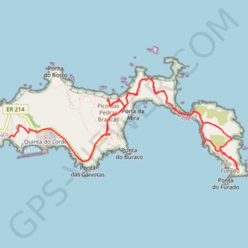
- Distance: 6.6 mi
- Elevation gain: 2,703 ft
- Maximum elevation: 410 ft
- Elevation loss: 2,907 ft
- Minimum elevation: -3 ft
Interactive map
GPS track profile
About this GPS track
Name: Pointe de Sao Laurenço GPS track, route, trail
Start: Ponta de São Lourenco, Caniçal, Machico, Madère, 9200-044, Portugal (32.74342 -16.70022)
Coordinates: 32.73900 -16.71546 32.75056 -16.68086
Other GPS tracks
Click on a GPS track to view route, its statistics and profile.
Madère - La presqu'île de Sao Lourenço
Randonnée pédestre. En aller-retour. #Randonnée #Madère #Atlantique #Mer #Océan
Distance: 4.9 mi • Elevation gain: 2,231 ft • Maximum elevation: 351 ft
La Ponta de São Lourenço
Distance: 4.1 mi • Elevation gain: 1,942 ft • Maximum elevation: 335 ft
La Ponta de Sao Lourenço
Distance: 4.1 mi • Elevation gain: 1,942 ft • Maximum elevation: 335 ft
Mad_14_Lourenco
Distance: 4.7 mi • Elevation gain: 2,198 ft • Maximum elevation: 348 ft
"Madeira" - 120 km Inselquerung mit allem was die Insel zu bieten hat!
Distance: 66.9 mi • Elevation gain: 31,765 ft • Maximum elevation: 5,925 ft
Madère - La presqu'île de Sao Lourenço
Distance: 4.9 mi • Elevation gain: 2,192 ft • Maximum elevation: 351 ft
Trail Planner Map
Distance: 4.7 mi • Elevation gain: 2,293 ft • Maximum elevation: 367 ft