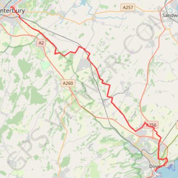
01: Canterbury – Dover (Developed)
Developed
- Distance: 21.0 mi
- Elevation gain: 778 ft
- Maximum elevation: 420 ft
- Elevation loss: 797 ft
- Minimum elevation: 16 ft
Interactive map
GPS track profile
About this GPS track
Name: 01: Canterbury – Dover (Developed) GPS track, route, trail
End: Esplanade, Clarendon, Dover, Douvres, Kent, Angleterre, CT17 9FS, Royaume-Uni (51.11998 1.31279)
Coordinates: 51.11998 1.08348 51.28369 1.33261
Other GPS tracks
Click on a GPS track to view route, its statistics and profile.
1: Canterbury – Dover (Developed)
Royaume-Uni > Angleterre > Kent > Cantorbéry
Developed
Distance: 21.6 mi • Elevation gain: 1,398 ft • Maximum elevation: 423 ft
VF-01-1 Via Francigena - 01 part Great Britain
Royaume-Uni > Angleterre > Kent > Cantorbéry
Distance: 47.8 mi • Elevation gain: 1,729 ft • Maximum elevation: 413 ft