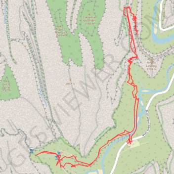
Angels Landing and Emerald Pools (Zion Canyon)
Hike from West Rim Trailhead to Angels Landing and Emerald Pools via West Rim Trail, Virgin River, Scout Lookout, Kayenta Trail, Lower Emerald Pool, Middle Emerald Pool and Upper Emerald Pool in the Zion National Park. #Hike #Canyon #Zion #Nature #River #Rock #Falls
- Distance: 6.9 mi
- Elevation gain: 4,216 ft
- Maximum elevation: 5,338 ft
- Elevation loss: 4,213 ft
- Minimum elevation: 4,285 ft
Interactive map
GPS track profile
About this GPS track
Name: Angels Landing and Emerald Pools (Zion Canyon) GPS track, route, trail
Coordinates: 37.25582 -112.96618 37.27593 -112.94996
Topography: Washington County topographic map, elevation, terrain
Other GPS tracks
Click on a GPS track to view its route, statistics and profile.
West Rim Trail to Scout Lookout in Zion National Park
United States > Utah > Washington County > Zion Lodge
Starting with a steady climb after crossing the Virgin River, the West Rim Trail winds through the Refrigerator Canyon before the real challenge begins. Tackling the tight switchbacks of Walter’s Wiggles, you’re rewarded with sweeping views of Zion’s dramatic cliffs, and finally at Scout Lookout, the…
Distance: 4.0 mi • Elevation gain: 1,818 ft • Maximum elevation: 5,433 ft
Angels Landing via West Rim Trail and Scout Lookout in Zion National Park
United States > Utah > Washington County
Embarking on the Angels Landing via the West Rim Trail is an exhilarating adventure that promises both breathtaking views and a thrilling challenge. After crossing the bridge over the Virgin River, you’ll meander through stunning landscapes, with the coolness of Refrigerator Canyon offering a refreshing…
Distance: 4.9 mi • Elevation gain: 2,923 ft • Maximum elevation: 5,558 ft
Emerald Pools, Scout Lookout and Angels Landing
United States > Utah > Washington County > Zion Lodge
Hike from Zion Lodge to Emerald Pools and Angels Landing via Virgin River, Lower Emerald Pool Trail, Lower Emerald Pool, Upper Emerald Pool, Kayenta Trail, West Rim Trail and Angels Landing Trail in the Zion Canyon and the Zion National Park. #Hike #Canyon #River #Rock #Park #Zion #Nature #Overlook
Distance: 6.0 mi • Elevation gain: 2,861 ft • Maximum elevation: 5,538 ft
Scout Lookout, Emerald Pools, View on the Patriarchs (Zion Canyon)
United States > Utah > Washington County > Zion Lodge
Hike in the Zion Canyon via West Rim Trail, Scout Lookout, Kayenta Trail, Upper Emerald Pool, Lower Emerald Pool, Virgin River, Sand Bench Trail and View on the Patriarchs. #Hike #Canyon #River #Nature #Rock #Mountain #Park #Zion
Distance: 10.3 mi • Elevation gain: 4,629 ft • Maximum elevation: 5,614 ft