M-TM_25K
- Distance: 15.8 mi
- Elevation gain: 2,579 ft
- Maximum elevation: 3,176 ft
- Elevation loss: 4,186 ft
- Minimum elevation: 213 ft
Interactive map
GPS track profile
About this GPS track
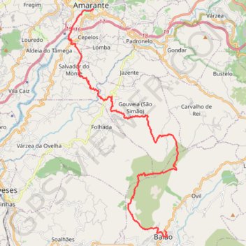
Name: M-TM_25K GPS track, route, trail
Coordinates: 41.16143 -8.09447 41.26796 -8.02620
Topography: Porto topographic map
Other GPS tracks
Click on a GPS track to view route, its statistics and profile.
Percorrer a Estrada N2 (Chaves - Faro)
Distance: 451.3 mi • Elevation gain: 36,289 ft • Maximum elevation: 3,202 ft
Percorrer a Estrada N2 (Chaves - Faro)
https://en-hk.gps-viewer.com/track-xhw5k/Percorrer-a-Estrada-N2-Chaves-Faro/
Distance: 451.4 mi • Elevation gain: 34,570 ft • Maximum elevation: 3,202 ft
Estrada Nacional 2 'Faro a Chaves' (EN2) Traçado Completo
Toda esta EN 2 é uma manta de "patchwork", com uma variedade de relevos e paisagens, gentes e culturas, incomparável com qualquer outra Estrada de Portugal. Cruza alguns dos mais importantes rios de Portugal e Ibéricos, com destaque, nomeadamente, para o Mondego e o Zêzere, para o Tejo e o Douro. Várias Serras fazem parte deste…
Distance: 445.7 mi • Elevation gain: 32,766 ft • Maximum elevation: 3,199 ft
Estrada Nacional 2 de Faro a Chaves (Traçado Completo)
Distance: 446.8 mi • Elevation gain: 36,745 ft • Maximum elevation: 3,209 ft
Southern section — European Divide Trail
France > Auvergne-Rhône-Alpes > Drôme > Valence
Distance: 1,506.1 mi • Elevation gain: 139,026 ft • Maximum elevation: 6,578 ft
T-n222.a.melhor.estrada.do.mundo_andar.de.coiso
Portugal > Porto > Vila Nova de Gaia
Distance: 141.5 mi • Elevation gain: 17,858 ft • Maximum elevation: 2,398 ft
Eurovelo 01 Spain + Portugal
France > Nouvelle-Aquitaine > Pyrénées-Atlantiques > Hendaye
Distance: 1,930.7 mi • Elevation gain: 100,367 ft • Maximum elevation: 4,931 ft
Volta Nortenha - Maia / Valença / Gerês / Bragança / Mogadou...
Distance: 554.7 mi • Elevation gain: 86,745 ft • Maximum elevation: 4,888 ft
Percorrer a Estrada N2 (Chaves - Faro)
Distance: 451.4 mi • Elevation gain: 34,646 ft • Maximum elevation: 3,192 ft
Percorrer a Estrada N2 (Chaves - Faro)
Distance: 451.4 mi • Elevation gain: 34,646 ft • Maximum elevation: 3,192 ft
Trace Portugal: La National 2 de Chaves à Faro
Distance: 445.8 mi • Elevation gain: 33,760 ft • Maximum elevation: 3,196 ft
Stage 26: Valence to Saint-Jean-de-Fos — European Divide Trail
France > Auvergne-Rhône-Alpes > Drôme > Valence
Distance: 1,506.1 mi • Elevation gain: 139,026 ft • Maximum elevation: 6,578 ft
Percorrer a Estrada N2 (Chaves - Faro)
Distance: 451.4 mi • Elevation gain: 34,646 ft • Maximum elevation: 3,192 ft
Braga para Miradouro Do Ujo
Distance: 213.2 mi • Elevation gain: 24,567 ft • Maximum elevation: 3,419 ft
LLOR2022_Final_10K_CP
Portugal > Faro > Vila Real de Santo António > Monte Gordo
Distance: 587.8 mi • Elevation gain: 66,362 ft • Maximum elevation: 3,707 ft