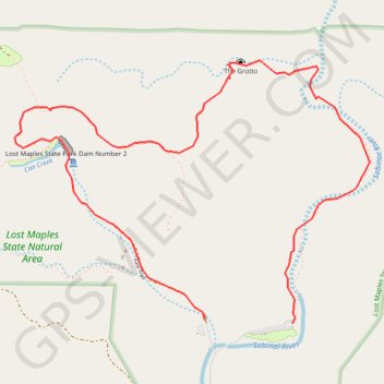
Lost Maples State Natural Area Loop
Loop hike in Lost Maples State Natural Area via East Trail, The Grotto, Birds Eye View, Can Creek and Lost Maples State Dam. #Hike #Loop #Nature #Forest #Mountain #Overlook #River #Park
- Distance: 4.1 mi
- Elevation gain: 633 ft
- Maximum elevation: 2,254 ft
- Elevation loss: 646 ft
- Minimum elevation: 1,827 ft
- Moving time: 2 h 57 m
- Moving speed: 1.4 mph
- Maximum speed: 3.2 mph
- Total time: 3 h 18 m
- Global speed: 1.2 mph
- Date: 11/12/2020
Interactive map
GPS track profile
About this GPS track
Name: Lost Maples State Natural Area Loop GPS track, route, trail
Start: East Trail, Bandera County, Texas, 78885, United States (29.81661 -99.57085)
End: East Trail, Bandera County, Texas, 78885, United States (29.81679 -99.57644)
Coordinates: 29.81661 -99.58862 29.83120 -99.56590
Topography: Bandera County topographic map