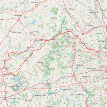
Hudson Snack Loop
Assabat River Trail Hudson -> Maynard
- Distance: 64.4 mi
- Elevation gain: 2,415 ft
- Maximum elevation: 459 ft
- Elevation loss: 2,415 ft
- Minimum elevation: 7 ft
- Moving time: 5 h 28 m
- Moving speed: 11.8 mph
- Maximum speed: 26.1 mph
- Total time: 5 h 31 m
- Global speed: 11.7 mph
- Date: 03/14/2024
Interactive map
GPS track profile
About this GPS track
Name: Hudson Snack Loop GPS track, route, trail
Coordinates: 42.34003 -71.57105 42.48612 -71.13320
Topography: Middlesex County topographic map
Other GPS tracks
Click on a GPS track to view route, its statistics and profile.
BruceFreemen and MCRT in Sudbury
United States > Massachusetts > Middlesex County > Newton
Sudbury sections of Bruce Freeman and new MCRT section from Union St
Distance: 52.8 mi • Elevation gain: 2,280 ft • Maximum elevation: 295 ft
Cambridge - Providence Express
United States > Massachusetts > Middlesex County > Cambridge
Alewife -> Providence
Distance: 63.2 mi • Elevation gain: 3,153 ft • Maximum elevation: 351 ft