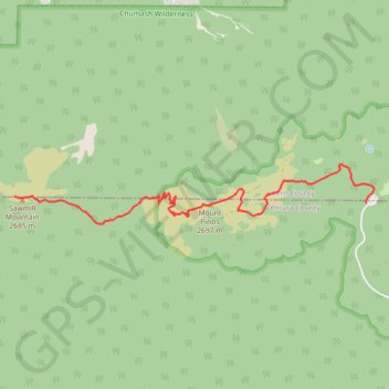
Sawmill Mountain and Mount Pinos
Hike to Sawmill Mountain via Mount Pinos Condor Observation Site from Chula Vista Parking in the Chumash Wilderness. #Hike #Mountain #Nature #Forest #Wilderness
- Distance: 3.7 mi
- Elevation gain: 1,020 ft
- Maximum elevation: 8,832 ft
- Elevation loss: 607 ft
- Minimum elevation: 8,360 ft
Interactive map
GPS track profile
About this GPS track
Name: Sawmill Mountain and Mount Pinos GPS track, route, trail
End: Vincent Tumamait Trail, Kern County, California, 93222, United States (34.81364 -119.16798)
Coordinates: 34.81098 -119.16798 34.81666 -119.12625
Topography: Kern County topographic map