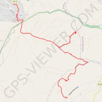
Cappadoce Ortahisar-Mustafapasa
Randonnée pédestre. #Randonnée
- Distance: 7.1 mi
- Elevation gain: 981 ft
- Maximum elevation: 4,062 ft
- Elevation loss: 1,132 ft
- Minimum elevation: 3,593 ft
- Moving time: 3 h 16 m
- Moving speed: 2.2 mph
- Maximum speed: 15.8 mph
- Total time: 5 h 18 m
- Global speed: 1.3 mph
- Date: 04/24/2013
Interactive map
GPS track profile
About this GPS track
Name: Cappadoce Ortahisar-Mustafapasa GPS track, route, trail
Coordinates: 38.58978 34.86333 38.62564 34.89973
Other GPS tracks
Click on a GPS track to view route, its statistics and profile.
Turkish port to Turkish border (Next to van)
Distance: 1,101.8 mi • Elevation gain: 63,881 ft • Maximum elevation: 8,238 ft
Randonnée cappadoce - étape 3 - Cavusin - uchisar - Ortahisar
Randonnée pédestre. En aller simple. #Randonnée
Distance: 12.4 mi • Elevation gain: 2,333 ft • Maximum elevation: 4,826 ft