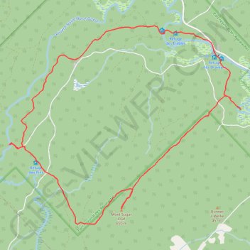
Parc Régional des Appalaches - 2ème jour
Randonnée en boucle depuis Saint-Adalbert. #Randonnée #Boucle
- Distance: 8.4 mi
- Elevation gain: 1,306 ft
- Maximum elevation: 2,090 ft
- Elevation loss: 1,319 ft
- Minimum elevation: 1,217 ft
- Moving time: 4 h 35 m
- Moving speed: 1.8 mph
- Maximum speed: 3.3 mph
- Total time: 6 h 16 m
- Global speed: 1.3 mph
- Date: 05/22/2011
Interactive map
GPS track profile
About this GPS track
Name: Parc Régional des Appalaches - 2ème jour GPS track, route, trail
Coordinates: 46.74112 -70.12821 46.77235 -70.07506
Other GPS tracks
Click on a GPS track to view route, its statistics and profile.
Parc Régional des Appalaches - 1er jour
Canada > Québec > Montmagny (MRC) > Sainte-Lucie-de-Beauregard
Randonnée entre Sainte-Lucie-de-Beauregard et Saint-Adalbert. #Randonnée
Distance: 4.2 mi • Elevation gain: 213 ft • Maximum elevation: 1,302 ft