Confinement ou isolement
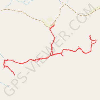
- Distance: 4.8 mi
- Elevation gain: 541 ft
- Maximum elevation: 1,378 ft
- Elevation loss: 538 ft
- Minimum elevation: 1,171 ft
- Moving time: 3 h 1 m
- Moving speed: 1.6 mph
- Maximum speed: 4.0 mph
- Total time: 5 h 57 m
- Global speed: 0.8 mph
- Date: 03/27/2020
Interactive map
GPS track profile
About this GPS track
Name: Confinement ou isolement GPS track, route, trail
Start: Ras el Khaïmah, Émirats arabes unis (25.10039 56.08546)
End: Ras el Khaïmah, Émirats arabes unis (25.10049 56.08529)
Coordinates: 25.09172 56.07567 25.10052 56.09354