Sherbrooke Cyclisme
Single track en partie
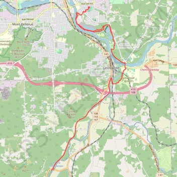
- Distance: 17.8 mi
- Elevation gain: 863 ft
- Maximum elevation: 650 ft
- Elevation loss: 863 ft
- Minimum elevation: 469 ft
- Moving time: 1 h 53 m
- Moving speed: 9.4 mph
- Maximum speed: 28.4 mph
- Total time: 2 h 9 m
- Global speed: 8.2 mph
- Date: 04/27/2024
Interactive map
GPS track profile
About this GPS track
Name: Sherbrooke Cyclisme GPS track, route, trail
Start: 700, Place Des Ormeaux, Fleurimont, Sherbrooke, Estrie, Québec, J1G 3L5, Canada (45.39411 -71.87128)
End: 700, Place Des Ormeaux, Fleurimont, Sherbrooke, Estrie, Québec, J1G 3L5, Canada (45.39415 -71.87128)
Coordinates: 45.31831 -71.89611 45.39469 -71.84659
Other GPS tracks
Click on a GPS track to view route, its statistics and profile.