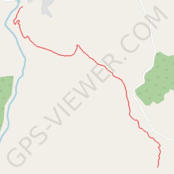
T2020-03-08-13-31
- Distance: 1.2 mi
- Elevation gain: 791 ft
- Maximum elevation: 1,273 ft
- Elevation loss: 36 ft
- Minimum elevation: 515 ft
- Moving time: 44 m 55 s
- Moving speed: 1.6 mph
- Maximum speed: 4.4 mph
- Total time: 49 m 18 s
- Global speed: 1.5 mph
- Date: 03/08/2020
Interactive map
GPS track profile
About this GPS track
Name: T2020-03-08-13-31 GPS track, route, trail
Coordinates: 35.50993 -5.34154 35.51980 -5.33048
Other GPS tracks
Click on a GPS track to view route, its statistics and profile.
Maroc en boucle depuis Tanger
Maroc > pachalik de Tanger > Tanger
Distance: 1,882.0 mi • Elevation gain: 89,413 ft • Maximum elevation: 7,549 ft
Ceuta -> Ouarzazat -> Ceuta espagne
Distance: 500.0 mi • Elevation gain: 31,946 ft • Maximum elevation: 7,188 ft
Saved
Maroc > cercle de Tétouan > Zaïtoune
Distance: 4.5 mi • Elevation gain: 3,645 ft • Maximum elevation: 3,953 ft