Flower route
- Distance: 38.8 mi
- Elevation gain: 433 ft
- Maximum elevation: 59 ft
- Elevation loss: 433 ft
- Minimum elevation: -3 ft
Interactive map
GPS track profile
About this GPS track
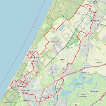
Name: Flower route GPS track, route, trail
Coordinates: 52.17865 4.39060 52.31492 4.58413
Other GPS tracks
Click on a GPS track to view route, its statistics and profile.
Rando Paris-Amsterdam
France > Île-de-France > Paris
Vélo. En aller simple entre Paris et Amsterdam. #Vélo
Distance: 442.2 mi • Elevation gain: 14,229 ft • Maximum elevation: 810 ft
Itinéraire de Hoofdweg 182III, 1057 DD Amsterdam, Pays-Bas à 9 Rue Louguet, 62100 Calais, France
Pays-Bas > Hollande-Septentrionale > Amsterdam
Distance: 221.2 mi • Elevation gain: 2,884 ft • Maximum elevation: 69 ft
Anvers anvers
Belgique > Anvers > Anvers > Stabroek
Distance: 263.6 mi • Elevation gain: 1,086 ft • Maximum elevation: 85 ft
Joop Zoetemelk Classic 150 km 2020
Netherlands > South Holland > Leiden
Distance: 88.6 mi • Elevation gain: 581 ft • Maximum elevation: 13 ft