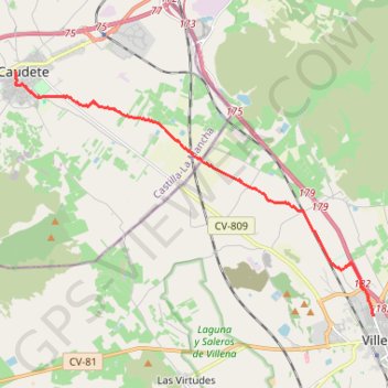
SE04-Villena-Caudete
Total: 15.1km
- Distance: 8.9 mi
- Elevation gain: 246 ft
- Maximum elevation: 1,850 ft
- Elevation loss: 82 ft
- Minimum elevation: 1,644 ft
Interactive map
GPS track profile
About this GPS track
Name: SE04-Villena-Caudete GPS track, route, trail
End: Plaza de San Cristóbal, Caudete, Albacete, Castille-La Manche, 02660, Espagne (38.70610 -0.98963)
Coordinates: 38.64224 -0.98963 38.70632 -0.86887
Other GPS tracks
Click on a GPS track to view route, its statistics and profile.
Southern section — European Divide Trail
France > Auvergne-Rhône-Alpes > Drôme > Valence
Distance: 1,506.1 mi • Elevation gain: 139,026 ft • Maximum elevation: 6,578 ft
1 LUCENA - MONTPELLIER
Distance: 1,842.0 mi • Elevation gain: 96,785 ft • Maximum elevation: 3,438 ft
1 LUCENA - MONTPELLIER
Espagne > Andalousie > Lucena
Distance: 1,842.0 mi • Elevation gain: 96,785 ft • Maximum elevation: 3,438 ft
Stage 26: Valence to Saint-Jean-de-Fos — European Divide Trail
France > Auvergne-Rhône-Alpes > Drôme > Valence
Distance: 1,506.1 mi • Elevation gain: 139,026 ft • Maximum elevation: 6,578 ft
Stage 26: Valence to Saint-Jean-de-Fos — European Divide Trail
France > Auvergne-Rhône-Alpes > Drôme > Valence
Distance: 1,012.7 mi • Elevation gain: 101,184 ft • Maximum elevation: 6,578 ft