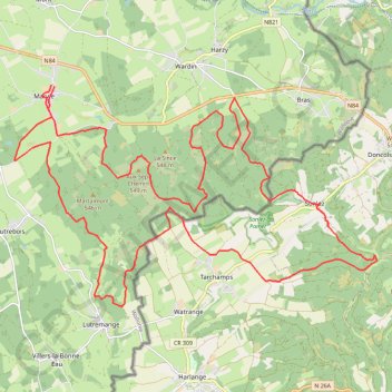
VTT - La Bastognarde 🐗
- Distance: 21.1 mi
- Elevation gain: 2,431 ft
- Maximum elevation: 1,808 ft
- Elevation loss: 2,434 ft
- Minimum elevation: 1,224 ft
- Moving time: 2 h 53 m
- Moving speed: 7.3 mph
- Maximum speed: 29.8 mph
- Total time: 3 h 4 m
- Global speed: 6.8 mph
- Date: 09/04/2022
Interactive map
GPS track profile
About this GPS track
Name: VTT - La Bastognarde 🐗 GPS track, route, trail
Start: 99, Marvie, Bastogne, Luxembourg, Wallonie, 6600, Belgique (49.98656 5.74621)
End: Marvie, Wardin, Bastogne, Luxembourg, Wallonie, 6600, Belgique (49.98634 5.74711)
Coordinates: 49.94454 5.73549 49.98656 5.84215
Other GPS tracks
Click on a GPS track to view route, its statistics and profile.
Tour d'Europe
France > Bretagne > Finistère > Concarneau > Landan Creis
Distance: 4,432.2 mi • Elevation gain: 146,335 ft • Maximum elevation: 7,982 ft
Eurovelo 15 - Entire Route
Pays-Bas > Hollande-Méridionale > Hoek van Holland
Distance: 903.2 mi • Elevation gain: 27,156 ft • Maximum elevation: 6,716 ft
Rhin par la rive gauche
Suisse > Uri > Korporation Ursern > Andermatt
Vélo. En aller simple entre Andermatt et Hoek van Holland. Suisse centrale. #Vélo #SuisseCentrale #Alpes #Montagne #Nature
Distance: 903.8 mi • Elevation gain: 22,533 ft • Maximum elevation: 6,716 ft
Tracé 568
Luxembourg > Canton Wiltz > Wiltz > Roullingen > Lameschmillen
Distance: 16.3 mi • Elevation gain: 2,526 ft • Maximum elevation: 1,594 ft
Rhin par la rive gauche
Suisse > Uri > Korporation Ursern > Andermatt
Distance: 903.6 mi • Elevation gain: 20,518 ft • Maximum elevation: 6,726 ft
Tour du GDL en ce jour de fête nationale !
Belgique > Luxembourg > Arlon > Nobressart
Distance: 218.1 mi • Elevation gain: 17,680 ft • Maximum elevation: 1,834 ft
RAF 2022 / 2600 n1 News
France > Hauts-de-France > Pas-de-Calais > Le Touquet-Paris-Plage
Distance: 1,612.3 mi • Elevation gain: 130,331 ft • Maximum elevation: 9,075 ft
Lille Bruxelles à Vélo
France > Hauts-de-France > Nord > Lille
Vélo. En aller simple entre Lille et Wiltz. #Vélo
Distance: 206.0 mi • Elevation gain: 10,682 ft • Maximum elevation: 1,785 ft
Stage 14: Frederikshavn to Aars — European Divide Trail
Danemark > Jutland du Nord > Frederikshavn
Distance: 1,382.7 mi • Elevation gain: 94,114 ft • Maximum elevation: 4,557 ft
Lille Nancy J1
France > Hauts-de-France > Nord > Lambersart
Distance: 257.4 mi • Elevation gain: 10,240 ft • Maximum elevation: 1,204 ft
Eurovelo 15 - Strasbourg Rotterdam
France > Grand Est > Bas-Rhin > Strasbourg
comment ...
Distance: 554.1 mi • Elevation gain: 7,021 ft • Maximum elevation: 479 ft
Eurovéloroute-15-Route-du-Rhin
Suisse > Uri > Korporation Ursern > Andermatt
Distance: 931.4 mi • Elevation gain: 22,854 ft • Maximum elevation: 6,713 ft
Merlimont (62155), Pas-de-Calais, Hauts-de-France, France - Nice (06000-06300), Alpes-Maritimes, France
France > Hauts-de-France > Pas-de-Calais > Merlimont
Distance: 1,445.5 mi • Elevation gain: 38,990 ft • Maximum elevation: 1,719 ft
Eurovelo 15 - Entire Route
Pays-Bas > Hollande-Méridionale > Hoek van Holland
Distance: 903.5 mi • Elevation gain: 25,433 ft • Maximum elevation: 6,726 ft
VoyageBelgique
France > Grand Est > Moselle > Metz
Distance: 237.1 mi • Elevation gain: 11,230 ft • Maximum elevation: 1,768 ft
Trk1 Maas-Radweg
France > Grand Est > Haute-Marne > Le Châtelet-sur-Meuse > Ferme Febvre
Distance: 325.9 mi • Elevation gain: 12,497 ft • Maximum elevation: 1,430 ft
Megève - Ohain
France > Auvergne-Rhône-Alpes > Haute-Savoie > Megève
<p>De Route de Rochebrune, 74120 Megève, Auvergne-Rhône-Alpes, France<br/> À Chemin du Moulin, 1380 Ohain, Belgique</p> <p>Routage Moto - le plus joli</p>
Distance: 493.9 mi • Elevation gain: 29,961 ft • Maximum elevation: 4,452 ft
25 septembre
France > Grand Est > Ardennes > Haybes
Distance: 148.0 mi • Elevation gain: 14,127 ft • Maximum elevation: 1,867 ft
20230902_190927
France > Grand Est > Moselle > Metz
Distance: 172.7 mi • Elevation gain: 9,820 ft • Maximum elevation: 1,854 ft
Itinéraire de Ham-sur-Heure-Nalinnes à Le Bonhomme
Belgique > Hainaut > Thuin > Ham-sur-Heure
Distance: 282.9 mi • Elevation gain: 14,616 ft • Maximum elevation: 3,127 ft
Marche-en-Famenne
Belgique > Luxembourg > Marche-en-Famenne > Marche-en-Famenne
<p>From Rue Dupont 46, 6900 Marche-en-Famenne, Belgium<br/> To Avenue de France, 6900 Marche-en-Famenne, Belgium</p> <p>Routing Motor - nicest</p>
Distance: 1,766.8 mi • Elevation gain: 94,672 ft • Maximum elevation: 3,537 ft
Eurovelo 15 - Entire Route
Pays-Bas > Hollande-Méridionale > Hoek van Holland
Distance: 903.5 mi • Elevation gain: 25,433 ft • Maximum elevation: 6,726 ft
Eurovelo 15 - Strasbourg Rotterdam
France > Grand Est > Bas-Rhin > Strasbourg
Distance: 554.1 mi • Elevation gain: 6,903 ft • Maximum elevation: 479 ft
De Guirsch à Gendron (définitif) J1
Belgique > Luxembourg > Arlon > Arlon > Guirsch
Distance: 628.8 mi • Elevation gain: 40,561 ft • Maximum elevation: 2,277 ft
De Guirsch à Gendron
Belgique > Luxembourg > Arlon > Arlon > Guirsch
Distance: 613.6 mi • Elevation gain: 41,873 ft • Maximum elevation: 2,277 ft
BA22 19 km
Belgique > Luxembourg > Bastogne > Bastogne > Wardin
Distance: 11.7 mi • Elevation gain: 1,342 ft • Maximum elevation: 1,811 ft
GR005_Parcours-principal_2021-05-06
Netherlands > Limburg > Maastricht
GR005_Parcours-principal_2021-05-06
Distance: 205.8 mi • Elevation gain: 29,472 ft • Maximum elevation: 1,877 ft
Jour 19 / 28 Juin 2022 (Final)
Distance: 548.6 mi • Elevation gain: 26,273 ft • Maximum elevation: 3,123 ft
Riethoven naar Oostenrijk
Netherlands > North Brabant > Riethoven > Eind
Distance: 573.0 mi • Elevation gain: 44,715 ft • Maximum elevation: 6,224 ft
Sortie ZAK 02-07-22
Luxembourg > Canton Capellen > Mamer
Distance: 158.0 mi • Elevation gain: 15,420 ft • Maximum elevation: 1,785 ft