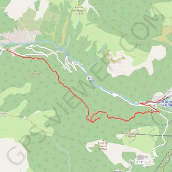
Lac des Mesches - Saint Dalmas de Tende
Randonnée depuis Tende. #Randonnée #Mercantour #Argentera #Alpes #Montagne #Nature
- Distance: 4.9 mi
- Elevation gain: 568 ft
- Maximum elevation: 4,482 ft
- Elevation loss: 2,726 ft
- Minimum elevation: 2,290 ft
- Moving time: 2 h 30 m
- Moving speed: 2.0 mph
- Maximum speed: 4.1 mph
- Total time: 6 h 37 m
- Global speed: 0.7 mph
- Date: 07/02/2015
Interactive map
GPS track profile
About this GPS track
Name: Lac des Mesches - Saint Dalmas de Tende GPS track, route, trail
Coordinates: 44.04993 7.53034 44.06718 7.58324
Other GPS tracks
Click on a GPS track to view route, its statistics and profile.
HexaTrekGPX
France > Nouvelle-Aquitaine > Pyrénées-Atlantiques > Hendaye
Distance: 1,670.4 mi • Elevation gain: 452,047 ft • Maximum elevation: 9,675 ft
Haute route du sel
Italie > Piémont > Coni > Limone Piemonte
projet de trace à tester, je validerai après le 15 aout .Il y a des restrictions de roulage pour certains jours se renseigner avant Une partie de l'itinéraire a un droit de passage de 15? pour moto quad et voiture
Distance: 92.0 mi • Elevation gain: 22,067 ft • Maximum elevation: 7,359 ft
Tour d'Europe
France > Bretagne > Finistère > Concarneau > Landan Creis
Distance: 4,432.2 mi • Elevation gain: 146,335 ft • Maximum elevation: 7,982 ft
Eurovelo 6
France > Pays de la Loire > Loire-Atlantique > Saint-Brevin-les-Pins
Distance: 2,815.0 mi • Elevation gain: 59,196 ft • Maximum elevation: 2,808 ft
GR52A Tende - Saorge
France > Provence-Alpes-Côte d'Azur > Alpes-Maritimes > Tende
https://fr-fr.gps-viewer.com/track-4m21h/GR52A-Tende-Saorge/
Distance: 33.2 mi • Elevation gain: 13,392 ft • Maximum elevation: 5,066 ft
1-Dolomites-Le Pradet - Sondrio
France > Provence-Alpes-Côte d'Azur > Var > Le Pradet > Village du Pradet
Distance: 684.4 mi • Elevation gain: 95,463 ft • Maximum elevation: 9,072 ft
TET-FRANCE-Section04- 20190827
Italie > Ligurie > Imperia > Olivetta > Olivetta San Michele
Distance: 640.4 mi • Elevation gain: 91,089 ft • Maximum elevation: 6,152 ft
3-Misurina, Auronzo di Cadore - Le Pradet
Italie > Vénétie > Belluno > Auronzo di Cadore > Misurina
Distance: 686.2 mi • Elevation gain: 96,348 ft • Maximum elevation: 7,208 ft
GR52A Tende - Saorge
France > Provence-Alpes-Côte d'Azur > Alpes-Maritimes > Tende
https://fr-fr.gps-viewer.com/track-4m21h/GR52A-Tende-Saorge/
Distance: 44.5 mi • Elevation gain: 17,234 ft • Maximum elevation: 5,066 ft
GR52A Tende - Saorge
France > Provence-Alpes-Côte d'Azur > Alpes-Maritimes > Tende
Randonnée entre Tende et Saorge. Alpes maritimes et ligures. #Randonnée #Alpes #MontagneMaritimes #Ligures #Alpes #Montagne #Mercantour #Argentera #Nature
Distance: 14.9 mi • Elevation gain: 4,980 ft • Maximum elevation: 5,066 ft
1 LUCENA - MONTPELLIER
Distance: 1,842.0 mi • Elevation gain: 96,785 ft • Maximum elevation: 3,438 ft
1 LUCENA - MONTPELLIER
Espagne > Andalousie > Lucena
Distance: 1,842.0 mi • Elevation gain: 96,785 ft • Maximum elevation: 3,438 ft
Tende - Lac des Mesches - Tende
France > Provence-Alpes-Côte d'Azur > Alpes-Maritimes > Tende
Randonnée pédestre. #Randonnée #Alpes #Montagne #Mercantour #Nature
Distance: 13.3 mi • Elevation gain: 4,636 ft • Maximum elevation: 5,253 ft
Traversée Col de Tende - Vintimille
Italie > Piémont > Coni > Limone Piemonte
VTT. En aller simple entre Tende et Ventimiglia. Alpes maritimes et ligures. #VTT #Alpes #MontagneMaritimes #Ligures #Alpes #Montagne #Mercantour #Argentera #Nature
Distance: 68.3 mi • Elevation gain: 15,354 ft • Maximum elevation: 7,562 ft
De Giromagny à Sofia
France > Bourgogne-Franche-Comté > Territoire-de-Belfort > Giromagny
Distance: 1,165.7 mi • Elevation gain: 39,724 ft • Maximum elevation: 3,458 ft
Euro 6
France > Pays de la Loire > Loire-Atlantique > Saint-Brevin-les-Pins
Distance: 2,634.6 mi • Elevation gain: 52,064 ft • Maximum elevation: 2,808 ft
Circuit de gravel de ta life
France > Provence-Alpes-Côte d'Azur > Alpes-Maritimes > Nice
Distance: 161.2 mi • Elevation gain: 41,312 ft • Maximum elevation: 7,359 ft
Limone - Ventimiglia
Italie > Piémont > Coni > Limone Piemonte
Distance: 66.1 mi • Elevation gain: 12,441 ft • Maximum elevation: 7,356 ft
Hexatrek_Parcours_Complet_NOBO
France > Nouvelle-Aquitaine > Pyrénées-Atlantiques > Hendaye
Distance: 1,669.6 mi • Elevation gain: 454,554 ft • Maximum elevation: 9,259 ft
Gravel tour du Marguareis La “strada dei Ladri”
France > Provence-Alpes-Côte d'Azur > Alpes-Maritimes > La Brigue
Total: 97.2km
Distance: 59.1 mi • Elevation gain: 12,943 ft • Maximum elevation: 7,359 ft
Hexatrek_Parcours_Complet_SOBO
Allemagne > Rhénanie-Palatinat > Arrondissement de la Route-du-Vin-du-Sud > Schweigen-Rechtenbach
Distance: 1,670.4 mi • Elevation gain: 454,117 ft • Maximum elevation: 9,278 ft
Enduro des merveilles
France > Provence-Alpes-Côte d'Azur > Alpes-Maritimes > Tende
Distance: 20.2 mi • Elevation gain: 5,561 ft • Maximum elevation: 4,419 ft
5 jours dans le Mercantour
France > Provence-Alpes-Côte d'Azur > Alpes-Maritimes > Tende
Distance: 46.2 mi • Elevation gain: 14,416 ft • Maximum elevation: 8,432 ft
HexaTrekGPX
France > Nouvelle-Aquitaine > Pyrénées-Atlantiques > Hendaye
Distance: 1,670.4 mi • Elevation gain: 452,047 ft • Maximum elevation: 9,675 ft
Etape2
France > Provence-Alpes-Côte d'Azur > Alpes-de-Haute-Provence > Jausiers
Distance: 161.4 mi • Elevation gain: 33,691 ft • Maximum elevation: 8,691 ft
PT23DS2 Lörrach → Cadaqués
Germany > Baden-Württemberg > Landkreis Lörrach > Lörrach
Distance: 652.9 mi • Elevation gain: 43,077 ft • Maximum elevation: 4,938 ft
LaBrigue_Tanarello_Tende
France > Provence-Alpes-Côte d'Azur > Alpes-Maritimes > La Brigue
Distance: 50.6 mi • Elevation gain: 11,896 ft • Maximum elevation: 7,362 ft
Tour de Suisse août V2
France > Provence-Alpes-Côte d'Azur > Bouches-du-Rhône > Marseille
Distance: 1,606.1 mi • Elevation gain: 168,038 ft • Maximum elevation: 8,130 ft
Itinéraire de Castries à Via Enrico Fermi, 1, 10028 Trofarello TO, Italie
France > Occitanie > Hérault > Castries
Distance: 280.9 mi • Elevation gain: 21,204 ft • Maximum elevation: 6,083 ft
Randonnée GR52
France > Provence-Alpes-Côte d'Azur > Alpes-Maritimes > Tende
Randonnée entre Tende et Saorge. Alpes maritimes et ligures. #Randonnée #Alpes #MontagneMaritimes #Ligures #Alpes #Montagne #Mercantour #Argentera #Nature
Distance: 15.3 mi • Elevation gain: 5,089 ft • Maximum elevation: 5,089 ft
Parte ovest
Italie > Piémont > Coni > Limone Piemonte
Statistiche calcolate sui dati importati<br><br>Distanza: 59,2 km
Distance: 37.1 mi • Elevation gain: 8,396 ft • Maximum elevation: 6,693 ft
Margareis_ColdeTende
France > Provence-Alpes-Côte d'Azur > Alpes-Maritimes > La Brigue
Distance: 24.0 mi • Elevation gain: 3,323 ft • Maximum elevation: 7,333 ft
La Brigue-Refuge de Nice
France > Provence-Alpes-Côte d'Azur > Alpes-Maritimes > La Brigue
Randonnée entre La Brigue et Belvédère. Alpes maritimes et ligures. #Randonnée #Alpes #MontagneMaritimes #Ligures #Alpes #Montagne #Mercantour #Argentera #Nature
Distance: 74.9 mi • Elevation gain: 37,395 ft • Maximum elevation: 8,337 ft
Randonnée Tende Saorge
France > Provence-Alpes-Côte d'Azur > Alpes-Maritimes > Tende
Randonnée entre Tende et Saorge. Alpes maritimes et ligures. #Randonnée #Alpes #MontagneMaritimes #Ligures #Alpes #Montagne #Mercantour #Argentera #Nature
Distance: 16.4 mi • Elevation gain: 5,256 ft • Maximum elevation: 5,089 ft
Marguarels
France > Provence-Alpes-Côte d'Azur > Alpes-Maritimes > Tende
VTT. En aller simple entre Tende et La Brigue. Alpes maritimes et ligures. #VTT #Alpes #MontagneMaritimes #Ligures #Mercantour #Argentera #Alpes #Montagne #Nature
Distance: 49.9 mi • Elevation gain: 12,900 ft • Maximum elevation: 7,352 ft
Refuge de Nice - La Brigue
France > Provence-Alpes-Côte d'Azur > Alpes-Maritimes > Belvédère
Randonnée entre Belvédère et La Brigue. Alpes maritimes et ligures. #Randonnée #Alpes #MontagneMaritimes #Ligures #Alpes #Montagne #Mercantour #Argentera #Nature
Distance: 46.4 mi • Elevation gain: 17,438 ft • Maximum elevation: 8,734 ft
Tour de la Roya
France > Provence-Alpes-Côte d'Azur > Alpes-Maritimes > La Brigue
Distance: 19.3 mi • Elevation gain: 6,411 ft • Maximum elevation: 5,259 ft