Rio de chillar espagne
Randonnée entre Nerja et Frigiliana. #Randonnée
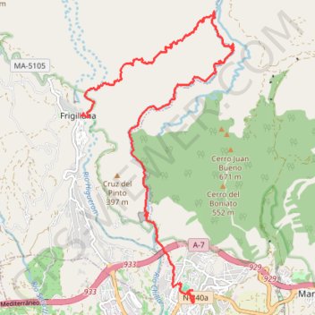
- Distance: 10.8 mi
- Elevation gain: 3,793 ft
- Maximum elevation: 1,706 ft
- Elevation loss: 3,071 ft
- Minimum elevation: 223 ft
- Moving time: 4 h 49 m
- Moving speed: 2.2 mph
- Maximum speed: 26.0 mph
- Total time: 5 d 23 h
- Global speed: 0.1 mph
- Date: 07/29/2015
Interactive map
GPS track profile
About this GPS track
Name: Rio de chillar espagne GPS track, route, trail
End: Calle San Sebastián, Frigiliana, La Axarquía, Malaga, Andalousie, 28788, Espagne (36.79087 -3.89482)
Coordinates: 36.75702 -3.89482 36.80964 -3.86023
Other GPS tracks
Click on a GPS track to view route, its statistics and profile.
Southern Section — European Divide Trail
Espagne > Andalousie > Cazorla
Distance: 516.0 mi • Elevation gain: 63,166 ft • Maximum elevation: 7,001 ft
Vila do Bispo -> Distrito 4 (495,2 km)
Distance: 811.8 mi • Elevation gain: 75,879 ft • Maximum elevation: 7,001 ft