Saddleback Mountain
Hike from Garden Parking Area to Saddleback Mountain via Phelps Trail, Orebed Brook Trail and State Range Trail in the Johns Brook Primitive Area, the High Peaks Wilderness and the Adirondack Park. #Hike #Mountain #Nature #Forest #River #Park #Wilderness
- Distance: 15.2 mi
- Elevation gain: 3,560 ft
- Maximum elevation: 4,465 ft
- Elevation loss: 3,566 ft
- Minimum elevation: 1,549 ft
Interactive map
GPS track profile
About this GPS track
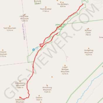
Name: Saddleback Mountain GPS track, route, trail
Coordinates: 44.12520 -73.87543 44.18914 -73.81591
Topography: Essex County topographic map
Other GPS tracks
Click on a GPS track to view route, its statistics and profile.
Big Slide Mountain Loop
United States > New York > Essex County > Town of Keene
Lop hike from Garden Parking to Big Slide Mountain via Phelps Trail, Big Slide Trail, The Brothers Trail, Third Brother, Second Brother and First Brother in the High Peaks Wilderness. #Hike #Loop #Mountain #Nature #Wilderness
Distance: 9.0 mi • Elevation gain: 2,805 ft • Maximum elevation: 4,108 ft
Montréal - New York
Canada > Québec > Agglomération de Montréal > Montréal
Distance: 396.0 mi • Elevation gain: 13,563 ft • Maximum elevation: 988 ft