Toronto Cycling
- Distance: 24.3 mi
- Elevation gain: 1,168 ft
- Maximum elevation: 407 ft
- Elevation loss: 1,168 ft
- Minimum elevation: 236 ft
- Moving time: 2 h 10 m
- Moving speed: 11.1 mph
- Maximum speed: 28.6 mph
- Total time: 2 h 14 m
- Global speed: 10.8 mph
- Date: 04/01/2024
Interactive map
GPS track profile
About this GPS track
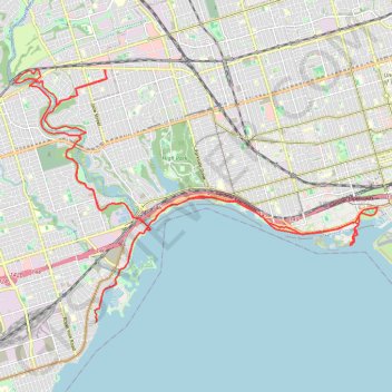
Name: Toronto Cycling GPS track, route, trail
Coordinates: 43.61080 -79.51136 43.66530 -79.40331
Other GPS tracks
Click on a GPS track to view route, its statistics and profile.
Brampton - Scarborough
Canada > Ontario > Peel Region > Brampton
Lake Ontario. #Bike #Brampton #Scarborough #Toronto #Ontario
Distance: 45.5 mi • Elevation gain: 1,870 ft • Maximum elevation: 604 ft
Hamilton - Toronto
#Bike
Distance: 50.5 mi • Elevation gain: 1,503 ft • Maximum elevation: 364 ft
Old mills to humber bay park
#Hike
Distance: 7.7 mi • Elevation gain: 246 ft • Maximum elevation: 315 ft